
TIM
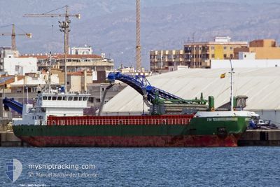
General Cargo
Current Trip
ORDER
| Time Travelled | 8 h, 30 mins |
|---|---|
| Remaining Time | --- |
| Distance Travelled | 88.17 nm |
| Remaining Distance | --- |
| AVG Speed | 9.4 Noeuds |
| MAX Speed | 13.5 Noeuds |
| AVG Wind | 14.1 knots |
| MAX Wind | 24 knots |
| MIN Temp | 6.6°C / 43.88°F |
| MAX Temp | 10.3°C / 50.54°F |
| Tirant d eau | 3.6 m |
| Position reçue | Maintenant |
Current Position
| Longitude | 1.06578° |
|---|---|
| Latitude | 53.04494° |
| Etat | Under way using engine |
| Vitesse | 10.1 Noeuds |
| Parcours | 121.7° |
| Zone | North Sea |
| Station | T-AIS |
| Position reçue | Maintenant |
Info
Information
The current position of TIM is in North Sea with coordinates 53.04494° / 1.06578° as reported on 2024-04-18 21:42 by AIS to our vessel tracker app. The vessel's current speed is 10.1 Noeuds
The vessel TIM (IMO: 9434151, MMSI: 212571000) is a General Cargo that was built in 2008 ( 16 Age ). It's sailing under the flag of [CY] Cyprus.
In this page you can find informations about the vessels current position, last detected port calls, and current voyage information. If the vessels is not in coverage by AIS you will find the latest position.
The current position of TIM is detected by our AIS receivers and we are not responsible for the reliability of the data. The last position was recorded while the vessel was in Coverage by the Ais receivers of our vessel tracking app.
The current draught of TIM as reported by AIS is 3.6 meters
Weather
| Temperature | 8°C / 46.4°F |
|---|---|
| Wind Speed | 24 knots |
| Direction | 250° WSW |
| Pressure | 1014.6 hPa |
| Humidity | 91.8 % |
| Cloud Coverage | 100 % |
Featured Company
Last Port Calls
| Port | Arrival | Departure | Time In Port |
|---|---|---|---|
| 2024-04-15 00:00 | 2024-04-18 13:13 | 3 d | |
| 2024-04-14 10:22 | 2024-04-14 18:52 | 8 h | |
| 2024-04-12 14:49 | 2024-04-12 18:10 | 3 h | |
| 2024-04-12 05:13 | 2024-04-12 05:52 | 38 m | |
| 2024-04-07 05:36 | 2024-04-10 11:17 | 3 d | |
| 2024-02-28 07:29 | 2024-03-07 11:43 | 8 d | |
| 2024-02-25 11:27 | 2024-02-26 16:07 | 1 d | |
| 2024-02-21 16:29 | 2024-02-23 21:06 | 2 d | |
| 2024-02-14 19:35 | 2024-02-16 22:53 | 2 d | |
| 2024-02-10 10:27 | 2024-02-13 00:03 | 2 d |
Last Trips
| Origin | Departure | Destination | Arrival | Distance | |
|---|---|---|---|---|---|
| 2024-04-14 19:52 | 2024-04-15 01:00 | 30.28 nm | |||
| 2024-04-12 20:10 | 2024-04-14 11:22 | 372.13 nm | |||
| 2024-04-12 07:52 | 2024-04-12 16:49 | 50.18 nm | |||
| 2024-04-10 14:17 | 2024-04-12 07:13 | 407.46 nm | |||
| 2024-03-07 12:43 | 2024-04-07 08:36 | 2676.27 nm | |||
| 2024-02-26 17:07 | 2024-02-28 08:29 | 358.65 nm | |||
| 2024-02-23 22:06 | 2024-02-25 12:27 | 353.21 nm | |||
| 2024-02-16 22:53 | 2024-02-21 17:29 | 1128.02 nm | |||
| 2024-02-13 00:03 | 2024-02-14 19:35 | 464.60 nm | |||
| 2024-02-05 22:58 | 2024-02-10 10:27 | 938.65 nm |
Events
| Heure | Evenement | Détails | Position/ Destination | Info |
|---|---|---|---|---|
| 2024-04-18 21:12 | Dans la zone couverte |
53.09782 / .96661
North Sea
|
Vitesse: 10.3 kn Parcours: 135.4° |
|
| 2024-04-18 17:38 | Hors de la zone couverte |
53.54248 / .19817
North Sea
|
Vitesse: 13.5 kn Parcours: 88.2° |
|
| 2024-04-18 16:31 | Etat Changé | Under way using engine Default |
53.62933 / -.13847
ORDER
|
Vitesse: 12.2 kn Parcours: 132° |
| 2024-04-18 16:30 | Etat Changé | Default Under way using engine |
53.63118 / -.14191
ORDER
|
Vitesse: 11.8 kn Parcours: 124.6° |
| 2024-04-18 13:13 | PORT DE DEPART |
|
53.69556 / -.86485
ORDER
|
Vitesse: 4.5 kn Parcours: 151° |
| 2024-04-18 13:12 | Démarrage |
53.69628 / -.86554
[GB] GOOLE
|
Vitesse: 3.3 kn Parcours: 151° |
|
| 2024-04-18 12:15 | Etat Changé | Under way using engine Moored |
53.69756 / -.87712
[GB] GOOLE
|
Vitesse: Parcours: 257° |
| 2024-04-17 21:13 | Etat Changé | Moored Default |
53.69758 / -.87713
[GB] GOOLE
|
Vitesse: Parcours: 258° |
| 2024-04-17 21:10 | Etat Changé | Default Moored |
53.69758 / -.87712
[GB] GOOLE
|
Vitesse: Parcours: 258° |
| 2024-04-16 12:01 | Etat Changé | Moored Default |
53.69757 / -.87713
[GB] GOOLE
|
Vitesse: Parcours: 258° |