
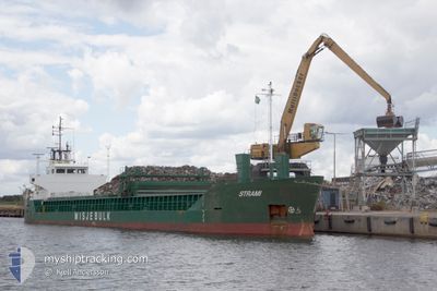
STRAMI
General Cargo
Current Trip
| Time Travelled | 17 h, 2 mins |
|---|---|
| Remaining Time | --- |
| Distance Travelled | 26.27 nm |
| Remaining Distance | --- |
| AVG Speed | 6.9 Noeuds |
| MAX Speed | 9.1 Noeuds |
| AVG Wind | 7 knots |
| MAX Wind | 9.5 knots |
| MIN Temp | 6.2°C / 43.16°F |
| MAX Temp | 11.2°C / 52.16°F |
| Tirant d eau | 3.5 m |
| Position reçue | 2 m depuis |
Current Position
| Longitude | -2.34028° |
|---|---|
| Latitude | 53.47764° |
| Etat | Moored |
| Vitesse | |
| Parcours | 249° |
| Zone | Irish Sea and St. George's Channel |
| Station | T-AIS |
| Position reçue | 2 m depuis |
Info
Information
The current position of STRAMI is in Irish Sea and St. George's Channel with coordinates 53.47764° / -2.34028° as reported on 2024-04-25 06:28 by AIS to our vessel tracker app. The vessel's current speed is 0 Noeuds and is heading at the port of MANCHESTER. The estimated time of arrival as calculated by MyShipTracking vessel tracking app is 2024-04-24 01:00 LT
The vessel STRAMI (IMO: 8922254, MMSI: 311973000) is a General Cargo that was built in 1992 ( 32 Age ). It's sailing under the flag of [BS] Bahamas.
In this page you can find informations about the vessels current position, last detected port calls, and current voyage information. If the vessels is not in coverage by AIS you will find the latest position.
The current position of STRAMI is detected by our AIS receivers and we are not responsible for the reliability of the data. The last position was recorded while the vessel was in Coverage by the Ais receivers of our vessel tracking app.
The current draught of STRAMI as reported by AIS is 3.5 meters
Weather
| Temperature | 5.3°C / 41.54°F |
|---|---|
| Wind Speed | 7 knots |
| Direction | 274° W |
| Pressure | 1005.2 hPa |
| Humidity | 85.4 % |
| Cloud Coverage | 98 % |
Featured Company
Last Port Calls
| Port | Arrival | Departure | Time In Port |
|---|---|---|---|
| 2024-04-24 13:16 | 2024-04-24 13:29 | 12 m | |
| 2024-04-24 12:22 | 2024-04-24 13:02 | 39 m | |
| 2024-04-24 00:45 | 2024-04-24 08:52 | 8 h | |
| 2024-04-12 22:39 | 2024-04-14 03:04 | 1 d | |
| 2024-04-07 19:27 | 2024-04-11 11:22 | 3 d | |
| 2024-04-05 23:33 | 2024-04-05 23:36 | 2 m | |
| 2024-03-27 13:43 | 2024-03-28 09:34 | 19 h | |
| 2024-03-24 05:38 | 2024-03-26 16:54 | 2 d | |
| 2024-03-11 14:33 | 2024-03-14 16:53 | 3 d | |
| 2024-03-06 07:14 | 2024-03-07 14:31 | 1 d |
Most Visited Ports (Last year)
| Port | Arrivals | |
|---|---|---|
| 5 | ||
| 5 | ||
| 4 | ||
| 4 | ||
| 4 | ||
| 4 |
Last Trips
| Origin | Departure | Destination | Arrival | Distance | |
|---|---|---|---|---|---|
| 2024-04-24 14:02 | 2024-04-24 14:16 | 1.86 nm | |||
| 2024-04-14 06:04 | 2024-04-24 13:22 | 1680.17 nm | |||
| 2024-04-14 06:04 | 2024-04-24 01:45 | 1652.22 nm | |||
| 2024-04-11 13:22 | 2024-04-13 01:39 | 150.06 nm | |||
| 2024-04-06 01:36 | 2024-04-07 21:27 | 400.29 nm | |||
| 2024-03-28 09:34 | 2024-04-06 01:33 | 1760.90 nm | |||
| 2024-03-26 16:54 | 2024-03-27 13:43 | 79.42 nm | |||
| 2024-03-14 16:53 | 2024-03-24 05:38 | 1828.80 nm | |||
| 2024-03-07 14:31 | 2024-03-11 14:33 | 592.62 nm | |||
| 2024-03-05 17:03 | 2024-03-06 07:14 | 139.85 nm |
Events
| Heure | Evenement | Détails | Position/ Destination | Info |
|---|---|---|---|---|
| 2024-04-24 19:58 | Etat Changé | Moored Under way using engine |
53.47765 / -2.34024
MANCHESTER
|
Vitesse: Parcours: 247° |
| 2024-04-24 19:43 | Arret | 17.64 nm, North East of RUNCORN |
53.47762 / -2.34029
MANCHESTER
|
Vitesse: 0.2 kn Parcours: 249° |
| 2024-04-24 18:54 | Démarrage | 16.1 nm, North East of RUNCORN |
53.46609 / -2.37874
MANCHESTER
|
Vitesse: 4.4 kn Parcours: 62° |
| 2024-04-24 18:25 | Arret | 15.99 nm, North East of RUNCORN |
53.46519 / -2.38147
MANCHESTER
|
Vitesse: 0.2 kn Parcours: 60° |
| 2024-04-24 18:04 | Démarrage | 14.47 nm, North East of RUNCORN |
53.44473 / -2.41017
MANCHESTER
|
Vitesse: 4.1 kn Parcours: 21° |
| 2024-04-24 17:45 | Arret | 14.37 nm, North East of RUNCORN |
53.44287 / -2.41126
MANCHESTER
|
Vitesse: 0.3 kn Parcours: 15° |
| 2024-04-24 16:48 | Démarrage | 8.44 nm, North East of RUNCORN |
53.38206 / -2.54398
MANCHESTER
|
Vitesse: 4.5 kn Parcours: 71° |
| 2024-04-24 16:28 | Arret | 8.32 nm, North East of RUNCORN |
53.38137 / -2.54707
MANCHESTER
|
Vitesse: 0.3 kn Parcours: 69° |
| 2024-04-24 16:17 | Démarrage | 7.89 nm, North East of RUNCORN |
53.37879 / -2.55811
MANCHESTER
|
Vitesse: 4.1 kn Parcours: 69° |
| 2024-04-24 15:19 | Arret | 7.78 nm, North East of RUNCORN |
53.37814 / -2.56106
MANCHESTER
|
Vitesse: 0.3 kn Parcours: 69° |