

STARVIP
General Cargo

Current Trip
LA CORUNA
| Time Travelled | 12 days |
|---|---|
| Remaining Time | --- |
| Distance Travelled | 546.15 nm |
| Remaining Distance | --- |
| AVG Speed | 8.2 Noeuds |
| MAX Speed | 11.9 Noeuds |
| AVG Wind | 8.6 knots |
| MAX Wind | 27.8 knots |
| MIN Temp | 9.2°C / 48.56°F |
| MAX Temp | 16.4°C / 61.52°F |
| Tirant d eau | 5.9 m |
| Position reçue | 3 d depuis |
Current Position
| Longitude | --- |
|---|---|
| Latitude | --- |
| Etat | Not under command |
| Vitesse | 2.5 Noeuds |
| Parcours | 186° |
| Zone | Bay of Biscay |
| Station | T-AIS |
| Position reçue | 3 d depuis |
Information
The current position of STARVIP is in Bay of Biscay with coordinates 43.78254° / -6.08511° as reported on 2025-02-24 09:39 by AIS to our vessel tracker app. The vessel's current speed is 2.5 Noeuds
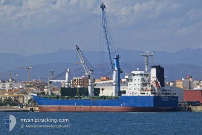
The vessel STARVIP (IMO: 9326495, MMSI: 256007000) is a General Cargo that was built in 2007 ( 18 Age ). It's sailing under the flag of [MT] Malta.
In this page you can find informations about the vessels current position, last detected port calls, and current voyage information. If the vessels is not in coverage by AIS you will find the latest position.
The current position of STARVIP is detected by our AIS receivers and we are not responsible for the reliability of the data. The last position was recorded while the vessel was in Coverage by the Ais receivers of our vessel tracking app.
The current draught of STARVIP as reported by AIS is 5.9 meters
Weather
| Temperature | 10.6°C / 51.08°F |
|---|---|
| Wind Speed | 18 knots |
| Direction | 77° ENE |
| Pressure | 1016.3 hPa |
| Humidity | 86.6 % |
| Cloud Coverage | 100 % |


Featured Company
Last Port Calls
| Port | Arrival | Departure | Time In Port |
|---|---|---|---|
| 2025-02-13 14:07 | 2025-02-14 20:38 | 1 d | |
| 2025-01-28 17:53 | 2025-02-01 17:57 | 4 d | |
| 2024-12-25 11:38 | 2024-12-27 17:05 | 2 d | |
| 2024-12-16 13:12 | 2024-12-16 13:34 | 22 m | |
| 2024-12-10 06:15 | 2024-12-15 09:24 | 5 d |
Last Trips
| Origin | Departure | Destination | Arrival | Distance | |
|---|---|---|---|---|---|
| 2025-02-01 17:57 | 2025-02-13 14:07 | 2627.56 nm | |||
| 2024-12-27 17:05 | 2025-01-28 17:53 | 1280.98 nm | |||
| 2024-12-16 13:34 | 2024-12-25 11:38 | 1219.52 nm | |||
| 2024-12-15 09:24 | 2024-12-16 13:12 | 263.81 nm | |||
| 2024-11-29 17:03 | 2024-12-10 06:15 | 1231.36 nm |
Events
| Heure | Evenement | Détails | Position/ Destination | Info |
|---|---|---|---|---|
| 2025-02-26 13:51 | Démarrage | 10.97 nm, North West of AVILES |
43.74956 / -6.05265
LA CORUNA
|
Vitesse: 6.6 kn Parcours: 277° |
| 2025-02-26 04:13 | Arret | 20.82 nm, North West of AVILES |
43.83398 / -6.26896
LA CORUNA
|
Vitesse: 0.3 kn Parcours: 190° |
| 2025-02-24 10:40 | Démarrage | 11.95 nm, North West of AVILES |
43.76853 / -6.05139
LA CORUNA
|
Vitesse: 3.1 kn Parcours: 213° |
| 2025-02-24 09:39 | Etat Changé | Default Not under command |
43.78251 / -6.08506
LA CORUNA
|
Vitesse: 2.5 kn Parcours: 186° |
| 2025-02-24 09:39 | Etat Changé | Not under command Default |
43.78254 / -6.08511
LA CORUNA
|
Vitesse: 1.2 kn Parcours: 187° |
| 2025-02-24 09:39 | Changement de zone | Spanish part of the Bay of Biscay Spanish part of the North Atlantic Ocean |
43.78254 / -6.08511
Bay of Biscay
|
Vitesse: 2.5 kn Parcours: 111° |
| 2025-02-24 09:39 | Hors de la zone couverte |
43.78254 / -6.08511
Bay of Biscay
|
Vitesse: 2.5 kn Parcours: 111° |
|
| 2025-02-24 09:36 | Dans la zone couverte |
43.78254 / -6.08511
Bay of Biscay
|
Vitesse: 2.5 kn Parcours: 111° |
|
| 2025-02-23 23:32 | Arret |
43.87544 / -6.39037
LA CORUNA
|
Vitesse: 0.3 kn Parcours: 211° |
|
| 2025-02-23 20:19 | Démarrage | 15.93 nm, North West of AVILES |
43.69820 / -6.26187
LA CORUNA
|
Vitesse: 3.1 kn Parcours: 338° |