
PUTLOS
Military ops
Current Trip
HEILIGENHAFEN
| Time Travelled | 9 h, 43 mins |
|---|---|
| Remaining Time | --- |
| Distance Travelled | 31.80 nm |
| Remaining Distance | --- |
| AVG Speed | 6 Noeuds |
| MAX Speed | 13.5 Noeuds |
| AVG Wind | 6.9 knots |
| MAX Wind | 10.9 knots |
| MIN Temp | 3.8°C / 38.84°F |
| MAX Temp | 7.3°C / 45.14°F |
| Tirant d eau | 2 m |
| Position reçue | 1 m depuis |
Current Position
| Longitude | 10.88188° |
|---|---|
| Latitude | 54.47566° |
| Etat | Under way using engine |
| Vitesse | 13.2 Noeuds |
| Parcours | 132.9° |
| Zone | Baltic Sea |
| Station | T-AIS |
| Position reçue | 1 m depuis |
Info
Information
The current position of PUTLOS is in Baltic Sea with coordinates 54.47566° / 10.88188° as reported on 2024-04-25 15:25 by AIS to our vessel tracker app. The vessel's current speed is 13.2 Noeuds
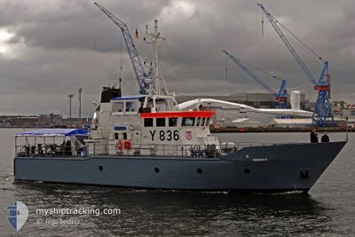
The vessel PUTLOS (MMSI: 211212690) is a Military ops It's sailing under the flag of [DE] Germany.
In this page you can find informations about the vessels current position, last detected port calls, and current voyage information. If the vessels is not in coverage by AIS you will find the latest position.
The current position of PUTLOS is detected by our AIS receivers and we are not responsible for the reliability of the data. The last position was recorded while the vessel was in Coverage by the Ais receivers of our vessel tracking app.
The current draught of PUTLOS as reported by AIS is 2 meters
Weather
| Temperature | 7.6°C / 45.68°F |
|---|---|
| Wind Speed | 7 knots |
| Direction | 144° SE |
| Pressure | 1002.6 hPa |
| Humidity | 70.2 % |
| Cloud Coverage | 100 % |
Featured Company
Last Port Calls
| Port | Arrival | Departure | Time In Port |
|---|---|---|---|
| 2024-04-24 13:34 | 2024-04-25 05:43 | 16 h | |
| 2024-04-23 13:32 | 2024-04-24 05:52 | 16 h | |
| 2024-04-22 14:08 | 2024-04-23 05:47 | 15 h | |
| 2024-04-19 06:09 | 2024-04-22 06:03 | 2 d | |
| 2024-04-18 14:47 | 2024-04-19 06:06 | 15 h | |
| 2024-04-17 15:27 | 2024-04-18 05:55 | 14 h | |
| 2024-04-15 14:55 | 2024-04-17 05:51 | 1 d | |
| 2024-04-11 15:30 | 2024-04-15 05:47 | 3 d | |
| 2024-04-10 15:04 | 2024-04-11 05:53 | 14 h | |
| 2024-04-09 15:13 | 2024-04-10 06:03 | 14 h |
Most Visited Ports (Last year)
| Port | Arrivals | |
|---|---|---|
| 13 | ||
| 1 |
Last Trips
| Origin | Departure | Destination | Arrival | Distance | |
|---|---|---|---|---|---|
| 2024-04-24 07:52 | 2024-04-24 15:34 | 21.91 nm | |||
| 2024-04-23 07:47 | 2024-04-23 15:32 | 50.68 nm | |||
| 2024-04-22 08:03 | 2024-04-22 16:08 | 21.46 nm | |||
| 2024-04-19 08:06 | 2024-04-19 08:09 | 0.37 nm | |||
| 2024-04-18 07:55 | 2024-04-18 16:47 | 21.69 nm | |||
| 2024-04-17 07:51 | 2024-04-17 17:27 | 31.91 nm | |||
| 2024-04-15 07:47 | 2024-04-15 16:55 | 34.32 nm | |||
| 2024-04-11 07:53 | 2024-04-11 17:30 | 27.73 nm | |||
| 2024-04-10 08:03 | 2024-04-10 17:04 | 51.74 nm | |||
| 2024-04-09 08:00 | 2024-04-09 17:13 | 18.85 nm |
Events
| Heure | Evenement | Détails | Position/ Destination | Info |
|---|---|---|---|---|
| 2024-04-25 15:00 | Démarrage | 12.98 nm, North West of HEILIGENHAFEN |
54.53715 / 10.76672
HEILIGENHAFEN
|
Vitesse: 3.1 kn Parcours: 29° |
| 2024-04-25 13:46 | Arret | 12.56 nm, North West of HEILIGENHAFEN |
54.53265 / 10.77599
HEILIGENHAFEN
|
Vitesse: 0.3 kn Parcours: 88° |
| 2024-04-25 13:08 | Changement de zone | German part of the Baltic Sea Danish part of the Baltic Sea |
54.54440 / 10.67703
Baltic Sea
|
Vitesse: 6.4 kn Parcours: 102.2° |
| 2024-04-25 12:57 | Démarrage | 14.93 nm, North East of WENDTORF |
54.54802 / 10.64307
HEILIGENHAFEN
|
Vitesse: 3.6 kn Parcours: 113° |
| 2024-04-25 12:56 | Changement de zone | Danish part of the Baltic Sea German part of the Baltic Sea |
54.54796 / 10.64231
Baltic Sea
|
Vitesse: 2.8 kn Parcours: 38.4° |
| 2024-04-25 12:02 | Arret | 14.42 nm, North East of WENDTORF |
54.54176 / 10.63228
HEILIGENHAFEN
|
Vitesse: 0.2 kn Parcours: 196° |
| 2024-04-25 12:00 | Démarrage | 14.45 nm, North East of WENDTORF |
54.54278 / 10.63244
HEILIGENHAFEN
|
Vitesse: 3.3 kn Parcours: 173° |
| 2024-04-25 11:23 | Arret | 14.37 nm, North East of WENDTORF |
54.54111 / 10.63116
HEILIGENHAFEN
|
Vitesse: 0.3 kn Parcours: 223° |
| 2024-04-25 11:17 | Démarrage | 14.63 nm, North East of WENDTORF |
54.54497 / 10.63588
HEILIGENHAFEN
|
Vitesse: 3.6 kn Parcours: 233° |
| 2024-04-25 10:18 | Arret | 14.36 nm, North East of WENDTORF |
54.54149 / 10.63078
HEILIGENHAFEN
|
Vitesse: 0.3 kn Parcours: 219° |