
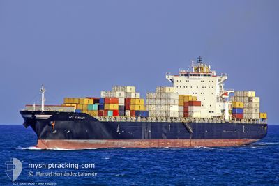
PUMBA
Container Ship
Current Trip
| Time Travelled | 10 days |
|---|---|
| Remaining Time | --- |
| Distance Travelled | 2403.91 nm |
| Remaining Distance | --- |
| AVG Speed | 14.7 Noeuds |
| MAX Speed | 17.2 Noeuds |
| AVG Wind | 14.3 knots |
| MAX Wind | 32.6 knots |
| MIN Temp | 5.6°C / 42.08°F |
| MAX Temp | 28.1°C / 82.58°F |
| Tirant d eau | 8.6 m |
| Position reçue | 9 d depuis |
Current Position
| Longitude | --- |
|---|---|
| Latitude | --- |
| Etat | Under way using engine |
| Vitesse | 15.9 Noeuds |
| Parcours | 83.4° |
| Zone | Singapore Strait |
| Station | T-AIS |
| Position reçue | 9 d depuis |
Info
Information
The current position of PUMBA is in Singapore Strait with coordinates 1.25428° / 104.17170° as reported on 2025-02-18 07:18 by AIS to our vessel tracker app. The vessel's current speed is 15.9 Noeuds
The vessel PUMBA (IMO: 9302566, MMSI: 636021329) is a Container Ship that was built in 2006 ( 19 Age ). It's sailing under the flag of [LR] Liberia.
In this page you can find informations about the vessels current position, last detected port calls, and current voyage information. If the vessels is not in coverage by AIS you will find the latest position.
The current position of PUMBA is detected by our AIS receivers and we are not responsible for the reliability of the data. The last position was recorded while the vessel was in Coverage by the Ais receivers of our vessel tracking app.
The current draught of PUMBA as reported by AIS is 8.6 meters
Weather
| Temperature | 12.4°C / 54.32°F |
|---|---|
| Wind Speed | 11 knots |
| Direction | 185° S |
| Pressure | 1018.1 hPa |
| Humidity | 92.4 % |
| Cloud Coverage | 100 % |
Featured Company
Last Port Calls
| Port | Arrival | Departure | Time In Port |
|---|---|---|---|
| 2025-02-17 01:19 | 2025-02-17 16:37 | 15 h | |
| 2025-02-03 06:29 | 2025-02-04 11:40 | 1 d | |
| 2025-01-31 21:01 | 2025-02-01 10:09 | 13 h | |
| 2025-01-28 06:22 | 2025-01-29 18:49 | 1 d | |
| 2025-01-23 12:25 | 2025-01-24 23:18 | 1 d | |
| 2025-01-22 14:26 | 2025-01-23 03:38 | 13 h | |
| 2025-01-20 16:45 | 2025-01-21 14:43 | 21 h | |
| 2025-01-18 03:01 | 2025-01-19 01:32 | 22 h | |
| 2025-01-17 11:00 | 2025-01-17 20:39 | 9 h | |
| 2024-12-29 04:57 | 2024-12-29 21:45 | 16 h |
Most Visited Ports (Last year)
| Port | Arrivals | |
|---|---|---|
| 10 | ||
| 5 | ||
| 4 | ||
| 4 | ||
| 4 | ||
| 4 |
Last Trips
| Origin | Departure | Destination | Arrival | Distance | |
|---|---|---|---|---|---|
| 2025-02-04 14:40 | 2025-02-17 09:19 | 4254.77 nm | |||
| 2025-01-29 21:49 | 2025-02-03 09:29 | 1086.93 nm | |||
| 2025-01-29 21:49 | 2025-01-31 23:01 | 370.95 nm | |||
| 2025-01-25 02:18 | 2025-01-28 09:22 | 821.92 nm | |||
| 2025-01-23 06:38 | 2025-01-23 15:25 | 60.68 nm | |||
| 2025-01-21 17:43 | 2025-01-22 17:26 | 301.94 nm | |||
| 2025-01-19 03:32 | 2025-01-20 19:45 | 588.47 nm | |||
| 2024-12-30 05:45 | 2025-01-18 05:01 | 6631.31 nm | |||
| 2024-12-30 05:45 | 2025-01-17 13:00 | 6486.80 nm | |||
| 2024-12-25 22:17 | 2024-12-29 12:57 | 860.36 nm |
Events
| Heure | Evenement | Détails | Position/ Destination | Info |
|---|---|---|---|---|
| 2025-02-25 21:25 | Arret |
29.78623 / 122.74465
CNNGB
|
Vitesse: 0.3 kn Parcours: 21° |
|
| 2025-02-25 16:50 | Démarrage | 2.41 nm, North of NINGBO |
29.98384 / 121.83779
CNNGB
|
Vitesse: 3.7 kn Parcours: 236° |
| 2025-02-25 01:06 | Arret | 2.32 nm, North of NINGBO |
29.98284 / 121.84182
CNNGB
|
Vitesse: 0.2 kn Parcours: 331° |
| 2025-02-24 19:34 | Démarrage |
29.81437 / 122.74024
CNNGB
|
Vitesse: 3.5 kn Parcours: 190° |
|
| 2025-02-23 23:38 | Arret |
29.81470 / 122.73682
CNNGB
|
Vitesse: 0.2 kn Parcours: 16° |
|
| 2025-02-18 07:25 | Etat Changé | Default Under way using engine |
1.25804 / 104.20381
CNNGB
|
Vitesse: 15.9 kn Parcours: 83.4° |
| 2025-02-18 07:18 | Hors de la zone couverte |
1.25428 / 104.17170
Singapore Strait
CNNGB
|
Vitesse: 15.9 kn Parcours: 83.4° |
|
| 2025-02-18 05:08 | Tirant d'eau modifié | 8.6 9 |
1.05246 / 103.66328
CNNGB
|
Vitesse: 15.7 kn Parcours: 64.2° |
| 2025-02-18 05:08 | Changement de destination | CNNGB MYPKG |
1.05246 / 103.66328
CNNGB
|
Vitesse: 15.7 kn Parcours: 64.2° |
| 2025-02-18 05:08 | Changement d'ETA | 2025/02/24 00:00 2025/02/16 02:00 |
1.05246 / 103.66328
CNNGB
|
Vitesse: 15.7 kn Parcours: 64.2° |