
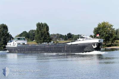
PATRIA
Cargo
Current Trip
ELST
| Time Travelled | 2 h, 7 mins |
|---|---|
| Remaining Time | --- |
| Distance Travelled | 12.87 nm |
| Remaining Distance | --- |
| AVG Speed | 10.1 Noeuds |
| MAX Speed | 10.3 Noeuds |
| AVG Wind | 14.8 knots |
| MAX Wind | 16 knots |
| MIN Temp | 7.5°C / 45.5°F |
| MAX Temp | 9.1°C / 48.38°F |
| Tirant d eau | 0.3 m |
| Position reçue | 50 m depuis |
Current Position
| Longitude | 5.49733° |
|---|---|
| Latitude | 51.88925° |
| Etat | Under way using engine |
| Vitesse | 10 Noeuds |
| Parcours | 268.3° |
| Zone | North Sea |
| Station | T-AIS |
| Position reçue | 50 m depuis |
Info
Information
The current position of PATRIA is in North Sea with coordinates 51.88925° / 5.49733° as reported on 2024-04-24 11:53 by AIS to our vessel tracker app. The vessel's current speed is 10 Noeuds
The vessel PATRIA (MMSI: 244750959) is a Cargo It's sailing under the flag of [NL] Netherlands.
In this page you can find informations about the vessels current position, last detected port calls, and current voyage information. If the vessels is not in coverage by AIS you will find the latest position.
The current position of PATRIA is detected by our AIS receivers and we are not responsible for the reliability of the data. The last position was recorded while the vessel was in Coverage by the Ais receivers of our vessel tracking app.
The current draught of PATRIA as reported by AIS is 0.3 meters
Weather
| Temperature | 9.2°C / 48.56°F |
|---|---|
| Wind Speed | 16 knots |
| Direction | 326° NW |
| Pressure | 1008.2 hPa |
| Humidity | 64.6 % |
| Cloud Coverage | 86 % |
Featured Company
Last Port Calls
| Port | Arrival | Departure | Time In Port |
|---|---|---|---|
| 2024-04-24 08:49 | 2024-04-24 10:36 | 1 h | |
| 2024-04-17 14:53 | 2024-04-18 11:57 | 21 h | |
| 2024-04-16 12:45 | 2024-04-17 08:58 | 20 h | |
| 2024-04-02 15:45 | 2024-04-03 11:35 | 19 h | |
| 2024-04-02 12:32 | 2024-04-02 14:23 | 1 h | |
| 2024-04-02 07:09 | 2024-04-02 11:21 | 4 h | |
| 2024-03-28 18:45 | 2024-04-02 03:48 | 4 d | |
| 2024-03-28 07:21 | 2024-03-28 07:26 | 4 m | |
| 2024-03-26 13:17 | 2024-03-26 13:21 | 3 m | |
| 2024-03-25 19:49 | 2024-03-26 05:15 | 9 h |
Last Trips
| Origin | Departure | Destination | Arrival | Distance | |
|---|---|---|---|---|---|
| 2024-04-18 13:57 | 2024-04-24 10:49 | 134.25 nm | |||
| 2024-04-17 10:58 | 2024-04-17 16:53 | 38.57 nm | |||
| 2024-04-03 13:35 | 2024-04-16 14:45 | 580.06 nm | |||
| 2024-04-02 16:23 | 2024-04-02 17:45 | 8.84 nm | |||
| 2024-04-02 13:21 | 2024-04-02 14:32 | 10.54 nm | |||
| 2024-04-02 05:48 | 2024-04-02 09:09 | 20.56 nm | |||
| 2024-03-28 08:26 | 2024-03-28 19:45 | 62.07 nm | |||
| 2024-03-26 14:21 | 2024-03-28 08:21 | 99.85 nm | |||
| 2024-03-26 06:15 | 2024-03-26 14:17 | 19.56 nm | |||
| 2024-03-25 10:06 | 2024-03-25 20:49 | 63.73 nm |
Events
| Heure | Evenement | Détails | Position/ Destination | Info |
|---|---|---|---|---|
| 2024-04-24 10:44 | Démarrage | 1.99 nm, North West of NIJMEGEN |
51.87618 / 5.79810
ELST
|
Vitesse: 10.2 kn Parcours: 286.7° |
| 2024-04-24 10:44 | Arret | 1.89 nm, North West of NIJMEGEN |
51.87547 / 5.80175
ELST
|
Vitesse: Parcours: 0° |
| 2024-04-24 10:36 | PORT DE DEPART |
|
51.86490 / 5.82688
ELST
|
Vitesse: 6.4 kn Parcours: 351.5° |
| 2024-04-24 10:27 | Démarrage |
51.85580 / 5.82453
[NL] NIJMEGEN
|
Vitesse: 3.4 kn Parcours: 23.9° |
|
| 2024-04-24 10:06 | Arret |
51.85416 / 5.82316
[NL] NIJMEGEN
|
Vitesse: 0.2 kn Parcours: 511° |
|
| 2024-04-24 10:02 | Démarrage |
51.85186 / 5.82136
[NL] NIJMEGEN
|
Vitesse: 3.1 kn Parcours: 22.9° |
|
| 2024-04-24 08:52 | Arret |
51.84907 / 5.81943
[NL] NIJMEGEN
|
Vitesse: 0.3 kn Parcours: 511° |
|
| 2024-04-24 08:49 | Port d'arrivée |
|
51.84866 / 5.81905
[NL] NIJMEGEN
|
Vitesse: 0.7 kn Parcours: 511° |
| 2024-04-24 07:16 | Dans la zone couverte |
51.71633 / 5.93470
North Sea
|
Vitesse: 8.6 kn Parcours: 286.1° |
|
| 2024-04-23 16:42 | Hors de la zone couverte |
51.10586 / 5.84863
North Sea
|
Vitesse: 7.3 kn Parcours: 27.6° |