
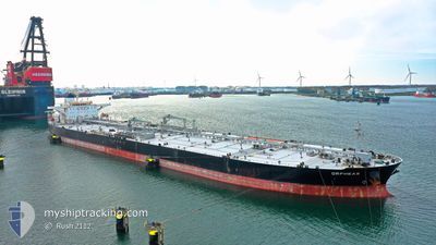
ORPHEAS
Crude Oil Tanker
Current Trip
| Time Travelled | 3 days |
|---|---|
| Remaining Time | 2 days |
| Distance Travelled | 1268.04 nm |
| Remaining Distance | 873.28 nm |
| AVG Speed | 12.7 Noeuds |
| MAX Speed | 15.2 Noeuds |
| AVG Wind | 8.5 knots |
| MAX Wind | 15 knots |
| MIN Temp | 11.3°C / 52.34°F |
| MAX Temp | 25.5°C / 77.9°F |
| Tirant d eau | 9.5 m |
| Position reçue | 3 h, 11 m depuis |
Current Position
| Longitude | -81.52478° |
|---|---|
| Latitude | 23.76779° |
| Etat | Under way using engine |
| Vitesse | 13.1 Noeuds |
| Parcours | 266.7° |
| Zone | North Atlantic Ocean |
| Station | T-AIS |
| Position reçue | 3 h, 11 m depuis |
Info
Information
The current position of ORPHEAS is in North Atlantic Ocean with coordinates 23.76779° / -81.52478° as reported on 2024-04-20 11:17 by AIS to our vessel tracker app. The vessel's current speed is 13.1 Noeuds and is heading at the port of CORPUS CHRISTI. The estimated time of arrival as calculated by MyShipTracking vessel tracking app is 2024-04-23 11:22 LT
The vessel ORPHEAS (IMO: 9318149, MMSI: 636013157) is a Crude Oil Tanker that was built in 2007 ( 17 Age ). It's sailing under the flag of [LR] Liberia.
In this page you can find informations about the vessels current position, last detected port calls, and current voyage information. If the vessels is not in coverage by AIS you will find the latest position.
The current position of ORPHEAS is detected by our AIS receivers and we are not responsible for the reliability of the data. The last position was recorded while the vessel was in Coverage by the Ais receivers of our vessel tracking app.
The current draught of ORPHEAS as reported by AIS is 9.5 meters
Weather
| Temperature | 25.5°C / 77.9°F |
|---|---|
| Wind Speed | 15 knots |
| Direction | 120° ESE |
| Pressure | 1018.4 hPa |
| Humidity | 69.8 % |
| Cloud Coverage | --- |
Featured Company
Last Port Calls
| Port | Arrival | Departure | Time In Port |
|---|---|---|---|
| 2024-04-14 17:40 | 2024-04-16 16:46 | 1 d | |
| 2024-04-11 05:51 | 2024-04-12 22:25 | 1 d |
Most Visited Ports (Last year)
| Port | Arrivals | |
|---|---|---|
| 2 | ||
| 2 | ||
| 1 | ||
| 1 | ||
| 1 | ||
| 1 |
Last Trips
| Origin | Departure | Destination | Arrival | Distance | |
|---|---|---|---|---|---|
| 2024-04-12 18:25 | 2024-04-14 13:40 | 148.21 nm | |||
| 2024-01-29 18:36 | 2024-04-11 01:51 | 5978.74 nm |
Events
| Heure | Evenement | Détails | Position/ Destination | Info |
|---|---|---|---|---|
| 2024-04-20 11:19 | Etat Changé | Default Under way using engine |
23.76667 / -81.53333
US CRP
|
Vitesse: 13.1 kn Parcours: 266.7° |
| 2024-04-20 11:17 | Hors de la zone couverte |
23.76779 / -81.52478
North Atlantic Ocean
US CRP
|
Vitesse: 13.1 kn Parcours: 266.7° |
|
| 2024-04-20 10:48 | Etat Changé | Under way using engine Default |
23.77215 / -81.40640
US CRP
|
Vitesse: 13.1 kn Parcours: 266° |
| 2024-04-20 10:19 | Etat Changé | Default Under way using engine |
23.77667 / -81.29333
US CRP
|
Vitesse: 13.1 kn Parcours: 267.9° |
| 2024-04-20 10:14 | Etat Changé | Under way using engine Default |
23.77786 / -81.27401
US CRP
|
Vitesse: 13.1 kn Parcours: 239° |
| 2024-04-20 09:45 | Etat Changé | Default Under way using engine |
23.82741 / -81.17159
US CRP
|
Vitesse: 13 kn Parcours: 238.3° |
| 2024-04-20 09:32 | Detecté en mer | Cuban part of the North Atlantic Ocean |
23.85199 / -81.12804
North Atlantic Ocean
US CRP
|
Vitesse: 12.9 kn Parcours: 238.2° |
| 2024-04-20 08:55 | Etat Changé | Under way using engine Default |
23.92055 / -81.00734
US CRP
|
Vitesse: 12 kn Parcours: 237° |
| 2024-04-20 08:52 | Etat Changé | Default Under way using engine |
23.92500 / -80.99667
US CRP
|
Vitesse: 12.6 kn Parcours: 237.8° |
| 2024-04-20 08:46 | Etat Changé | Under way using engine Default |
23.93871 / -80.97579
US CRP
|
Vitesse: 12 kn Parcours: 238° |