
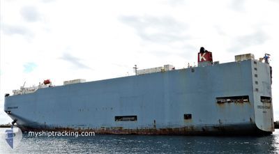
OREGON HIGHWAY
Vehicles Carrier
Current Trip
| Trip Time | --- |
|---|---|
| Trip Distance | --- |
| AVG Speed | --- |
| MAX Speed | --- |
| Tirant d eau | --- |
| AVG Wind | --- |
| MAX Wind | --- |
| MIN Temp | --- |
| MAX Temp | --- |
| Position reçue | 6 d depuis |
Current Position
| Longitude | 103.41247° |
|---|---|
| Latitude | 1.25095° |
| Etat | Under way using engine |
| Vitesse | 18.9 Noeuds |
| Parcours | 284° |
| Zone | Malacca Strait |
| Station | T-AIS |
| Position reçue | 6 d depuis |
Info
Information
The current position of OREGON HIGHWAY is in Malacca Strait with coordinates 1.25095° / 103.41247° as reported on 2024-04-14 12:15 by AIS to our vessel tracker app. The vessel's current speed is 18.9 Noeuds and is currently inside the port of HAMBANTOTA.
The vessel OREGON HIGHWAY (IMO: 9381665, MMSI: 352929000) is a Vehicles Carrier that was built in 2007 ( 17 Age ). It's sailing under the flag of [PA] Panama.
In this page you can find informations about the vessels current position, last detected port calls, and current voyage information. If the vessels is not in coverage by AIS you will find the latest position.
The current position of OREGON HIGHWAY is detected by our AIS receivers and we are not responsible for the reliability of the data. The last position was recorded while the vessel was in Coverage by the Ais receivers of our vessel tracking app.
The current draught of OREGON HIGHWAY as reported by AIS is 9.1 meters
Weather
| Temperature | 30°C / 86°F |
|---|---|
| Wind Speed | 11 knots |
| Direction | 238° WSW |
| Pressure | 1005.9 hPa |
| Humidity | 66.8 % |
| Cloud Coverage | 100 % |
Featured Company
Last Port Calls
| Port | Arrival | Departure | Time In Port |
|---|---|---|---|
| 2024-04-20 04:31 | |||
| 2024-04-18 05:19 | |||
| 2024-04-13 19:10 | 2024-04-14 10:27 | 15 h | |
| 2024-04-06 15:43 | 2024-04-07 02:53 | 11 h | |
| 2024-04-02 22:25 | 2024-04-03 08:23 | 9 h | |
| 2024-04-01 22:53 | 2024-04-02 21:25 | 22 h | |
| 2024-03-31 22:16 | 2024-04-01 08:13 | 9 h | |
| 2024-03-30 21:52 | 2024-03-31 08:02 | 10 h | |
| 2024-03-24 21:13 | 2024-03-26 08:34 | 1 d | |
| 2024-03-20 23:04 | 2024-03-21 09:54 | 10 h |
Last Trips
| Origin | Departure | Destination | Arrival | Distance | |
|---|---|---|---|---|---|
| 2024-04-14 18:27 | 2024-04-18 10:49 | 1589.86 nm | |||
| 2024-04-07 10:53 | 2024-04-14 03:10 | 2568.38 nm | |||
| 2024-04-03 17:23 | 2024-04-06 23:43 | 835.24 nm | |||
| 2024-04-03 06:25 | 2024-04-03 07:25 | 10.19 nm | |||
| 2024-04-01 17:13 | 2024-04-02 07:53 | 236.93 nm | |||
| 2024-03-31 17:02 | 2024-04-01 07:16 | 209.15 nm | |||
| 2024-03-26 17:34 | 2024-03-31 06:52 | 852.33 nm | |||
| 2024-03-21 17:54 | 2024-03-25 06:13 | 1136.36 nm | |||
| 2024-01-22 16:30 | 2024-03-21 07:04 | 15428.19 nm |
Events
| Heure | Evenement | Détails | Position/ Destination | Info |
|---|---|---|---|---|
| 2024-04-20 04:47 | Arret |
6.12957 / 81.09499
[LK] HAMBANTOTA
|
Vitesse: Parcours: 91° |
|
| 2024-04-20 04:31 | Port d'arrivée |
|
6.13028 / 81.09617
[LK] HAMBANTOTA
|
Vitesse: 10.1 kn Parcours: 325° |
| 2024-04-18 05:19 | Port d'arrivée |
|
13.27545 / 80.34203
[IN] ENNORE
|
Vitesse: 7 kn Parcours: 289° |
| 2024-04-14 12:18 | Etat Changé | Default Under way using engine |
1.25967 / 103.39750
IN ENR
|
Vitesse: 18.9 kn Parcours: 284° |
| 2024-04-14 12:15 | Hors de la zone couverte |
1.25095 / 103.41247
Malacca Strait
IN ENR
|
Vitesse: 18.9 kn Parcours: 284° |
|
| 2024-04-14 12:03 | Changement de zone | Malaysian part of the Malacca Strait Malaysian part of the Singapore Strait |
1.23718 / 103.47225
Malacca Strait
IN ENR
|
Vitesse: 18.1 kn Parcours: 282° |
| 2024-04-14 11:34 | Changement de zone | Malaysian part of the Singapore Strait Indonesian part of the Singapore Strait |
1.20238 / 103.59437
Singapore Strait
IN ENR
|
Vitesse: 13.2 kn Parcours: 281° |
| 2024-04-14 11:22 | Changement de zone | Indonesian part of the Singapore Strait Singaporean part of the Singapore Strait |
1.19982 / 103.63602
Singapore Strait
IN ENR
|
Vitesse: 10.7 kn Parcours: 262° |
| 2024-04-14 10:29 | Démarrage | 2.58 nm, North of BUKOM ISLAND |
1.27918 / 103.74632
IN ENR
|
Vitesse: 3.1 kn Parcours: 181° |
| 2024-04-14 10:27 | PORT DE DEPART |
|
1.28005 / 103.74640
IN ENR
|
Vitesse: 2.1 kn Parcours: 181° |