
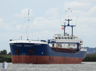
MONIKA
General Cargo
Current Trip
| Time Travelled | 1 day |
|---|---|
| Remaining Time | 2 h, 27 mins |
| Distance Travelled | 252.07 nm |
| Remaining Distance | 64.76 nm |
| AVG Speed | 8.3 Noeuds |
| MAX Speed | 9.9 Noeuds |
| AVG Wind | 9.3 knots |
| MAX Wind | 15 knots |
| MIN Temp | 5.2°C / 41.36°F |
| MAX Temp | 6.3°C / 43.34°F |
| Tirant d eau | 4.8 m |
| Position reçue | 19 h, 15 m depuis |
Current Position
| Longitude | --- |
|---|---|
| Latitude | --- |
| Etat | Under way using engine |
| Vitesse | 9.1 Noeuds |
| Parcours | 83.2° |
| Zone | Kattegat |
| Station | T-AIS |
| Position reçue | 19 h, 15 m depuis |
Info
Information
The current position of MONIKA is in Kattegat with coordinates 55.44420° / 15.38942° as reported on 2025-12-06 15:50 by AIS to our vessel tracker app. The vessel's current speed is 9.1 Noeuds and is heading at the port of KLAIPEDA. The estimated time of arrival as calculated by MyShipTracking vessel tracking app is 2025-12-07 15:32 LT
The vessel MONIKA (IMO: 9115987, MMSI: 304482000) is a General Cargo that was built in 1995 ( 30 Age ). It's sailing under the flag of [AG] Antigua Barbuda.
In this page you can find informations about the vessels current position, last detected port calls, and current voyage information. If the vessels is not in coverage by AIS you will find the latest position.
The current position of MONIKA is detected by our AIS receivers and we are not responsible for the reliability of the data. The last position was recorded while the vessel was in Coverage by the Ais receivers of our vessel tracking app.
The current draught of MONIKA as reported by AIS is 4.8 meters
Weather
| Temperature | 6°C / 42.8°F |
|---|---|
| Wind Speed | 17 knots |
| Direction | 173° S |
| Pressure | 1012.7 hPa |
| Humidity | 87.8 % |
| Cloud Coverage | 100 % |
Featured Company
Last Port Calls
| Port | Arrival | Departure | Time In Port |
|---|---|---|---|
| 2025-12-04 06:04 | 2025-12-05 13:28 | 1 d | |
| 2025-12-02 14:13 | 2025-12-03 19:41 | 1 d | |
| 2025-11-28 23:00 | 2025-12-01 16:29 | 2 d | |
| 2025-11-24 19:36 | 2025-11-27 10:52 | 2 d | |
| 2025-11-21 14:17 | 2025-11-22 14:26 | 1 d | |
| 2025-11-20 09:28 | 2025-11-21 00:56 | 15 h | |
| 2025-11-17 06:48 | 2025-11-18 15:53 | 1 d | |
| 2025-11-14 18:57 | 2025-11-14 19:33 | 35 m | |
| 2025-11-12 07:28 | 2025-11-14 10:30 | 2 d | |
| 2025-11-11 23:35 | 2025-11-11 23:58 | 22 m |
Most Visited Ports (Last year)
| Port | Arrivals | |
|---|---|---|
| 2 | ||
| 2 | ||
| 2 | ||
| 2 | ||
| 2 | ||
| 2 |
Last Trips
| Origin | Departure | Destination | Arrival | Distance | |
|---|---|---|---|---|---|
| 2025-12-03 19:41 | 2025-12-04 06:04 | 92.70 nm | |||
| 2025-12-01 16:29 | 2025-12-02 14:13 | 183.15 nm | |||
| 2025-11-27 10:52 | 2025-11-28 23:00 | 120.78 nm | |||
| 2025-11-22 14:26 | 2025-11-24 19:36 | 438.72 nm | |||
| 2025-11-21 00:56 | 2025-11-21 14:17 | 118.15 nm | |||
| 2025-11-18 15:53 | 2025-11-20 09:28 | 422.35 nm | |||
| 2025-11-14 19:33 | 2025-11-17 06:48 | 519.32 nm | |||
| 2025-11-14 10:30 | 2025-11-14 18:57 | 65.04 nm | |||
| 2025-11-11 23:58 | 2025-11-12 07:28 | 65.83 nm | |||
| 2025-11-11 14:42 | 2025-11-11 23:35 | 85.95 nm |
Events
| Heure | Evenement | Détails | Position/ Destination | Info |
|---|---|---|---|---|
| 2025-12-06 15:57 | Etat Changé | Default Under way using engine |
55.44604 / 15.41941
LTKLJ
|
Vitesse: 9.1 kn Parcours: 83.2° |
| 2025-12-06 15:50 | Hors de la zone couverte |
55.44420 / 15.38942
Kattegat
LTKLJ
|
Vitesse: 9.1 kn Parcours: 83.2° |
|
| 2025-12-06 15:47 | Etat Changé | Under way using engine Default |
55.44335 / 15.37624
LTKLJ
|
Vitesse: 9.2 kn Parcours: 83° |
| 2025-12-06 15:08 | Etat Changé | Default Under way using engine |
55.43419 / 15.20358
LTKLJ
|
Vitesse: 9 kn Parcours: 85.3° |
| 2025-12-06 15:02 | Detecté en mer | Danish part of the Kattegat |
55.43277 / 15.17507
Kattegat
LTKLJ
|
Vitesse: 9 kn Parcours: 85.3° |
| 2025-12-06 15:02 | Etat Changé | Under way using engine Default |
55.43277 / 15.17507
LTKLJ
|
Vitesse: 9 kn Parcours: 85° |
| 2025-12-06 14:49 | Dans la zone couverte |
55.43277 / 15.17507
Kattegat
LTKLJ
|
Vitesse: 9 kn Parcours: 85.3° |
|
| 2025-12-06 10:39 | Changement d'ETA | 2025/12/07 12:00 2025/12/07 14:00 |
55.17447 / 14.19449
LTKLJ
|
Vitesse: 9.3 kn Parcours: 89° |
| 2025-12-06 04:45 | Etat Changé | Default Under way using engine |
55.28351 / 12.68614
LTKLJ
|
Vitesse: 9 kn Parcours: 117.3° |
| 2025-12-06 04:38 | Hors de la zone couverte |
55.29105 / 12.66128
Baltic Sea
LTKLJ
|
Vitesse: 9 kn Parcours: 117.3° |