

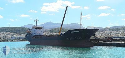
MERA QUEEN
Cargo

Current Trip
IT CTA
| Time Travelled | 3 h, 21 mins |
|---|---|
| Remaining Time | --- |
| Distance Travelled | 27.79 nm |
| Remaining Distance | --- |
| AVG Speed | 9.3 Noeuds |
| MAX Speed | 9.7 Noeuds |
| AVG Wind | 14.9 knots |
| MAX Wind | 18.8 knots |
| MIN Temp | 13.8°C / 56.84°F |
| MAX Temp | 15.8°C / 60.44°F |
| Tirant d eau | 5.4 m |
| Position reçue | 6 d depuis |
Current Position
| Longitude | --- |
|---|---|
| Latitude | --- |
| Etat | Under way using engine |
| Vitesse | 7.9 Noeuds |
| Parcours | 57.4° |
| Zone | Mediterranean Sea - Eastern Basin |
| Station | T-AIS |
| Position reçue | 6 d depuis |
Information
The current position of MERA QUEEN is in Mediterranean Sea - Eastern Basin with coordinates 36.33494° / 14.54661° as reported on 2025-02-21 15:36 by AIS to our vessel tracker app. The vessel's current speed is 7.9 Noeuds
The vessel MERA QUEEN (IMO: 9664108, MMSI: 630001066) is a Cargo It's sailing under the flag of [GW] Guinea-Bissau.
In this page you can find informations about the vessels current position, last detected port calls, and current voyage information. If the vessels is not in coverage by AIS you will find the latest position.
The current position of MERA QUEEN is detected by our AIS receivers and we are not responsible for the reliability of the data. The last position was recorded while the vessel was in Coverage by the Ais receivers of our vessel tracking app.
The current draught of MERA QUEEN as reported by AIS is 5.4 meters
Weather
| Temperature | 14.8°C / 58.64°F |
|---|---|
| Wind Speed | 13 knots |
| Direction | 308° NW |
| Pressure | 1017.3 hPa |
| Humidity | 67.5 % |
| Cloud Coverage | 15 % |


Featured Company
Last Port Calls
| Port | Arrival | Departure | Time In Port |
|---|---|---|---|
| 2025-02-22 06:31 | 2025-02-27 14:56 | 5 d | |
| 2025-02-19 07:21 | 2025-02-20 10:52 | 1 d | |
| 2025-02-12 21:13 | 2025-02-17 12:02 | 4 d | |
| 2025-01-26 19:10 | 2025-02-01 16:11 | 5 d | |
| 2025-01-23 17:40 | 2025-01-25 08:32 | 1 d | |
| 2024-12-30 09:28 | 2025-01-11 08:38 | 11 d | |
| 2024-12-23 08:39 | 2024-12-27 18:51 | 4 d | |
| 2024-12-10 00:31 | 2024-12-17 08:05 | 7 d |
Last Trips
| Origin | Departure | Destination | Arrival | Distance | |
|---|---|---|---|---|---|
| 2025-02-20 10:52 | 2025-02-22 06:31 | 327.05 nm | |||
| 2025-02-17 12:02 | 2025-02-19 07:21 | 360.03 nm | |||
| 2025-02-01 16:11 | 2025-02-12 21:13 | 542.33 nm | |||
| 2025-01-25 08:32 | 2025-01-26 19:10 | 284.20 nm | |||
| 2025-01-11 08:38 | 2025-01-23 17:40 | 1392.44 nm | |||
| 2024-12-27 18:51 | 2024-12-30 09:28 | 68.49 nm | |||
| 2024-12-17 08:05 | 2024-12-23 08:39 | 1069.99 nm | |||
| 2024-11-04 13:37 | 2024-12-10 00:31 | 2943.04 nm |
Events
| Heure | Evenement | Détails | Position/ Destination | Info |
|---|---|---|---|---|
| 2025-02-27 13:56 | Démarrage | 1.04 nm, South East of CATANIA |
37.47570 / 15.10620
IT CTA
|
Vitesse: 8.2 kn Parcours: 116° |
| 2025-02-27 13:56 | PORT DE DEPART |
|
37.47570 / 15.10620
IT CTA
|
Vitesse: 3.4 kn Parcours: 140° |
| 2025-02-22 05:48 | Arret |
37.49543 / 15.09317
[IT] CATANIA
|
Vitesse: 0.2 kn Parcours: 189° |
|
| 2025-02-22 05:31 | Port d'arrivée |
|
37.48640 / 15.09745
[IT] CATANIA
|
Vitesse: 3.9 kn Parcours: 342° |
| 2025-02-21 15:39 | Etat Changé | Default Under way using engine |
36.33889 / 14.55471
IT CTA
|
Vitesse: 7.9 kn Parcours: 57.4° |
| 2025-02-21 15:36 | Hors de la zone couverte |
36.33494 / 14.54661
Mediterranean Sea - Eastern Basin
IT CTA
|
Vitesse: 7.9 kn Parcours: 57.4° |
|
| 2025-02-21 15:27 | Etat Changé | Under way using engine Default |
36.32468 / 14.52641
IT CTA
|
Vitesse: 7.9 kn Parcours: 60° |
| 2025-02-21 15:24 | Etat Changé | Default Under way using engine |
36.32050 / 14.51864
IT CTA
|
Vitesse: 7.9 kn Parcours: 57.7° |
| 2025-02-21 12:19 | Tirant d'eau modifié | 5.4 3.5 |
36.08747 / 14.09892
IT CTA
|
Vitesse: 8.4 kn Parcours: 51.9° |
| 2025-02-21 12:19 | Changement de destination | IT CTA TN SFA |
36.08747 / 14.09892
IT CTA
|
Vitesse: 8.4 kn Parcours: 51.9° |