
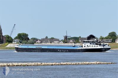
MASORA
Cargo
Current Trip
NA
| Time Travelled | 4 h, 10 mins |
|---|---|
| Remaining Time | --- |
| Distance Travelled | 34.18 nm |
| Remaining Distance | --- |
| AVG Speed | 8.5 Noeuds |
| MAX Speed | 9.4 Noeuds |
| AVG Wind | 5.2 knots |
| MAX Wind | 7 knots |
| MIN Temp | 5.7°C / 42.26°F |
| MAX Temp | 11.6°C / 52.88°F |
| Tirant d eau | 1 m |
| Position reçue | 8 m depuis |
Current Position
| Longitude | 8.34515° |
|---|---|
| Latitude | 49.87558° |
| Etat | Under way using engine |
| Vitesse | 8.5 Noeuds |
| Parcours | 339.5° |
| Zone | North Sea |
| Station | T-AIS |
| Position reçue | 8 m depuis |
Info
Information
The current position of MASORA is in North Sea with coordinates 49.87558° / 8.34515° as reported on 2024-04-25 19:26 by AIS to our vessel tracker app. The vessel's current speed is 8.5 Noeuds
The vessel MASORA (MMSI: 244050205) is a Cargo It's sailing under the flag of [NL] Netherlands.
In this page you can find informations about the vessels current position, last detected port calls, and current voyage information. If the vessels is not in coverage by AIS you will find the latest position.
The current position of MASORA is detected by our AIS receivers and we are not responsible for the reliability of the data. The last position was recorded while the vessel was in Coverage by the Ais receivers of our vessel tracking app.
The current draught of MASORA as reported by AIS is 1 meters
Weather
| Temperature | 6.9°C / 44.42°F |
|---|---|
| Wind Speed | 5 knots |
| Direction | 210° SSW |
| Pressure | 1006.5 hPa |
| Humidity | 65.6 % |
| Cloud Coverage | 100 % |
Featured Company
Last Port Calls
| Port | Arrival | Departure | Time In Port |
|---|---|---|---|
| 2024-04-24 18:58 | 2024-04-25 15:24 | 20 h | |
| 2024-04-21 19:09 | 2024-04-22 05:07 | 9 h | |
| 2024-04-21 07:28 | 2024-04-21 08:39 | 1 h | |
| 2024-04-19 10:18 | 2024-04-19 10:41 | 23 m | |
| 2024-04-19 03:32 | 2024-04-19 07:09 | 3 h | |
| 2024-04-18 16:15 | 2024-04-18 16:53 | 38 m | |
| 2024-04-17 20:30 | 2024-04-18 08:56 | 12 h | |
| 2024-04-17 10:40 | 2024-04-17 11:40 | 59 m | |
| 2024-04-11 16:20 | 2024-04-17 03:35 | 5 d | |
| 2024-04-09 07:08 | 2024-04-09 07:42 | 34 m |
Most Visited Ports (Last year)
| Port | Arrivals | |
|---|---|---|
| 21 | ||
| 20 | ||
| 14 | ||
| 12 | ||
| 12 | ||
| 12 |
Last Trips
| Origin | Departure | Destination | Arrival | Distance | |
|---|---|---|---|---|---|
| 2024-04-22 07:07 | 2024-04-24 20:58 | 130.80 nm | |||
| 2024-04-21 10:39 | 2024-04-21 21:09 | 45.04 nm | |||
| 2024-04-19 12:41 | 2024-04-21 09:28 | 138.38 nm | |||
| 2024-04-19 09:09 | 2024-04-19 12:18 | 17.71 nm | |||
| 2024-04-18 18:53 | 2024-04-19 05:32 | 25.09 nm | |||
| 2024-04-18 10:56 | 2024-04-18 18:15 | 55.11 nm | |||
| 2024-04-17 13:40 | 2024-04-17 22:30 | 76.89 nm | |||
| 2024-04-17 05:35 | 2024-04-17 12:40 | 60.61 nm | |||
| 2024-04-09 09:42 | 2024-04-11 18:20 | 291.21 nm | |||
| 2024-04-08 12:16 | 2024-04-09 09:08 | 11.83 nm |
Events
| Heure | Evenement | Détails | Position/ Destination | Info |
|---|---|---|---|---|
| 2024-04-25 15:24 | PORT DE DEPART |
|
49.44429 / 8.48967
NA
|
Vitesse: 8.3 kn Parcours: 294.6° |
| 2024-04-25 15:19 | Démarrage |
49.44098 / 8.50498
[DE] RHEINAU
|
Vitesse: 6.2 kn Parcours: 302.5° |
|
| 2024-04-24 18:58 | Arret |
49.43891 / 8.50962
[DE] RHEINAU
|
Vitesse: Parcours: 511° |
|
| 2024-04-24 18:58 | Port d'arrivée |
|
49.43891 / 8.50962
[DE] RHEINAU
|
Vitesse: 0.9 kn Parcours: 511° |
| 2024-04-24 16:34 | Dans la zone couverte |
49.59146 / 8.41619
North Sea
|
Vitesse: 5.7 kn Parcours: 151.9° |
|
| 2024-04-24 14:46 | Hors de la zone couverte |
49.71591 / 8.41965
North Sea
|
Vitesse: 5.9 kn Parcours: 256.1° |
|
| 2024-04-24 08:13 | Dans la zone couverte |
49.97214 / 7.89583
North Sea
|
Vitesse: 6.7 kn Parcours: 107.4° |
|
| 2024-04-24 06:56 | Hors de la zone couverte |
50.04257 / 7.79658
North Sea
|
Vitesse: 4.4 kn Parcours: 128.4° |
|
| 2024-04-24 06:55 | Dans la zone couverte |
50.04355 / 7.79461
North Sea
|
Vitesse: 4.3 kn Parcours: 127.2° |
|
| 2024-04-22 12:56 | Hors de la zone couverte |
50.48163 / 7.33916
North Sea
|
Vitesse: 4.2 kn Parcours: 143.1° |