
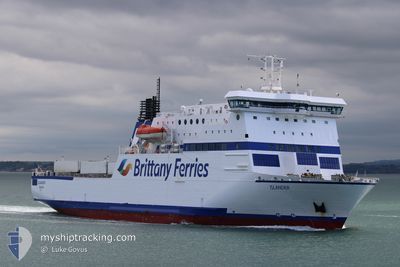
ISLANDER
Ro-Ro/Passenger Ship
Current Trip
| Time Travelled | 5 h, 55 mins |
|---|---|
| Remaining Time | 1 h, 57 mins |
| Distance Travelled | 78.11 nm |
| Remaining Distance | 30.06 nm |
| AVG Speed | 14.1 Noeuds |
| MAX Speed | 17.4 Noeuds |
| AVG Wind | 21.8 knots |
| MAX Wind | 28.2 knots |
| MIN Temp | 12.3°C / 54.14°F |
| MAX Temp | 13.6°C / 56.48°F |
| Tirant d eau | 5.2 m |
| Position reçue | 3 h, 11 m depuis |
Current Position
| Longitude | --- |
|---|---|
| Latitude | --- |
| Etat | Under way using engine |
| Vitesse | 12.6 Noeuds |
| Parcours | 205.7° |
| Zone | English Channel |
| Station | T-AIS |
| Position reçue | 3 h, 11 m depuis |
Info
Information
The current position of ISLANDER is in English Channel with coordinates 50.27268° / -1.35765° as reported on 2025-12-08 22:59 by AIS to our vessel tracker app. The vessel's current speed is 12.6 Noeuds and is heading at the port of GUERNSEY. The estimated time of arrival as calculated by MyShipTracking vessel tracking app is 2025-12-09 04:08 LT
The vessel ISLANDER (IMO: 9323704, MMSI: 311001287) is a Ro-Ro/Passenger Ship that was built in 2005 ( 20 Age ). It's sailing under the flag of [BS] Bahamas.
In this page you can find informations about the vessels current position, last detected port calls, and current voyage information. If the vessels is not in coverage by AIS you will find the latest position.
The current position of ISLANDER is detected by our AIS receivers and we are not responsible for the reliability of the data. The last position was recorded while the vessel was in Coverage by the Ais receivers of our vessel tracking app.
The current draught of ISLANDER as reported by AIS is 5.2 meters
Weather
| Temperature | 12.3°C / 54.14°F |
|---|---|
| Wind Speed | 28 knots |
| Direction | 181° S |
| Pressure | 1007.7 hPa |
| Humidity | 87.2 % |
| Cloud Coverage | 100 % |
Featured Company
Last Port Calls
| Port | Arrival | Departure | Time In Port |
|---|---|---|---|
| 2025-12-08 15:36 | 2025-12-08 20:16 | 4 h | |
| 2025-12-08 03:45 | 2025-12-08 08:20 | 4 h | |
| 2025-12-07 13:35 | 2025-12-07 20:06 | 6 h | |
| 2025-11-30 20:10 | 2025-12-07 09:55 | 6 d | |
| 2025-11-30 06:44 | 2025-11-30 10:18 | 3 h | |
| 2025-11-29 21:17 | 2025-11-29 23:06 | 1 h | |
| 2025-11-29 13:41 | 2025-11-29 15:32 | 1 h | |
| 2025-11-29 04:16 | 2025-11-29 07:47 | 3 h | |
| 2025-11-28 15:31 | 2025-11-28 20:21 | 4 h | |
| 2025-11-28 03:47 | 2025-11-28 08:22 | 4 h |
Most Visited Ports (Last year)
| Port | Arrivals | |
|---|---|---|
| 310 | ||
| 288 | ||
| 62 | ||
| 36 | ||
| 1 | ||
| 1 |
Last Trips
| Origin | Departure | Destination | Arrival | Distance | |
|---|---|---|---|---|---|
| 2025-12-08 08:20 | 2025-12-08 15:36 | 104.61 nm | |||
| 2025-12-07 20:06 | 2025-12-08 03:45 | 107.02 nm | |||
| 2025-12-07 09:55 | 2025-12-07 13:35 | 77.59 nm | |||
| 2025-11-30 10:18 | 2025-11-30 20:10 | 91.14 nm | |||
| 2025-11-29 23:06 | 2025-11-30 06:44 | 110.69 nm | |||
| 2025-11-29 15:32 | 2025-11-29 21:17 | 75.88 nm | |||
| 2025-11-29 07:47 | 2025-11-29 13:41 | 65.84 nm | |||
| 2025-11-28 20:21 | 2025-11-29 04:16 | 107.77 nm | |||
| 2025-11-28 08:22 | 2025-11-28 15:31 | 106.41 nm | |||
| 2025-11-27 20:10 | 2025-11-28 03:47 | 107.49 nm |
Events
| Heure | Evenement | Détails | Position/ Destination | Info |
|---|---|---|---|---|
| 2025-12-08 23:07 | Etat Changé | Default Under way using engine |
50.24852 / -1.37585
GUERNSEY
|
Vitesse: 12.6 kn Parcours: 205.7° |
| 2025-12-08 22:59 | Hors de la zone couverte |
50.27268 / -1.35765
English Channel
GUERNSEY
|
Vitesse: 12.6 kn Parcours: 205.7° |
|
| 2025-12-08 20:16 | PORT DE DEPART |
|
50.78667 / -1.10818
GUERNSEY
|
Vitesse: 10.2 kn Parcours: 160° |
| 2025-12-08 20:02 | Démarrage |
50.81179 / -1.09743
[GB] PORTSMOUTH
|
Vitesse: 4.4 kn Parcours: 260° |
|
| 2025-12-08 19:47 | Changement de destination | GUERNSEY PORTSMOUTH |
50.81239 / -1.09451
[GB] PORTSMOUTH
|
Vitesse: Parcours: 219° |
| 2025-12-08 19:47 | Changement d'ETA | 2025/12/09 04:00 2025/12/08 15:45 |
50.81239 / -1.09451
[GB] PORTSMOUTH
|
Vitesse: Parcours: 219° |
| 2025-12-08 19:47 | Etat Changé | Under way using engine Moored |
50.81239 / -1.09451
[GB] PORTSMOUTH
|
Vitesse: Parcours: 219° |
| 2025-12-08 15:50 | Etat Changé | Moored Under way using engine |
50.81238 / -1.09451
[GB] PORTSMOUTH
|
Vitesse: Parcours: 219° |
| 2025-12-08 15:48 | Arret |
50.81238 / -1.09454
[GB] PORTSMOUTH
|
Vitesse: 0.3 kn Parcours: 220° |
|
| 2025-12-08 15:36 | Port d'arrivée |
|
50.80825 / -1.11261
[GB] PORTSMOUTH
|
Vitesse: 7.2 kn Parcours: 51.2° |