
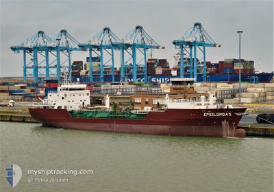
EPSILONGAS
Lpg Tanker
Current Trip
| Time Travelled | 24 days |
|---|---|
| Remaining Time | 6 days |
| Distance Travelled | 5384.73 nm |
| Remaining Distance | 1651.62 nm |
| AVG Speed | 9.5 Noeuds |
| MAX Speed | 14 Noeuds |
| AVG Wind | 12.3 knots |
| MAX Wind | 24 knots |
| MIN Temp | 10.9°C / 51.62°F |
| MAX Temp | 26°C / 78.8°F |
| Tirant d eau | 6.9 m |
| Position reçue | 9 m depuis |
Current Position
| Longitude | 0.25913° |
|---|---|
| Latitude | 36.74057° |
| Etat | Under way using engine |
| Vitesse | 10.8 Noeuds |
| Parcours | 69.1° |
| Zone | Mediterranean Sea - Western Basin |
| Station | T-AIS |
| Position reçue | 9 m depuis |
Info
Information
The current position of EPSILONGAS is in Mediterranean Sea - Western Basin with coordinates 36.74057° / 0.25913° as reported on 2024-04-25 01:24 by AIS to our vessel tracker app. The vessel's current speed is 10.8 Noeuds and is heading at the port of PORT SAID. The estimated time of arrival as calculated by MyShipTracking vessel tracking app is 2024-05-01 09:45 LT
The vessel EPSILONGAS (IMO: 9202039, MMSI: 304050864) is a Lpg Tanker that was built in 2000 ( 24 Age ). It's sailing under the flag of [AG] Antigua Barbuda.
In this page you can find informations about the vessels current position, last detected port calls, and current voyage information. If the vessels is not in coverage by AIS you will find the latest position.
The current position of EPSILONGAS is detected by our AIS receivers and we are not responsible for the reliability of the data. The last position was recorded while the vessel was in Coverage by the Ais receivers of our vessel tracking app.
The current draught of EPSILONGAS as reported by AIS is 6.9 meters
Weather
| Temperature | 16.3°C / 61.34°F |
|---|---|
| Wind Speed | 5 knots |
| Direction | 131° SE |
| Pressure | 1012.7 hPa |
| Humidity | 54.5 % |
| Cloud Coverage | 100 % |
Featured Company
Events
| Heure | Evenement | Détails | Position/ Destination | Info |
|---|---|---|---|---|
| 2024-04-25 01:32 | Etat Changé | Default Under way using engine |
36.74667 / .28667
EG PSD
|
Vitesse: 10.8 kn Parcours: 69.1° |
| 2024-04-25 01:15 | Etat Changé | Under way using engine Default |
36.73007 / .22598
EG PSD
|
Vitesse: 11 kn Parcours: 69° |
| 2024-04-25 01:11 | Etat Changé | Default Under way using engine |
36.72666 / .21333
EG PSD
|
Vitesse: 10.9 kn Parcours: 71.7° |
| 2024-04-25 00:44 | Etat Changé | Under way using engine Default |
36.69993 / .09880
EG PSD
|
Vitesse: 11 kn Parcours: 83° |
| 2024-04-25 00:29 | Etat Changé | Default Under way using engine |
36.69500 / .06333
EG PSD
|
Vitesse: 10.6 kn Parcours: 81.7° |
| 2024-04-24 23:07 | Etat Changé | Under way using engine Default |
36.63647 / -.23460
EG PSD
|
Vitesse: 11 kn Parcours: 74° |
| 2024-04-24 22:28 | Etat Changé | Default Under way using engine |
36.60450 / -.37168
EG PSD
|
Vitesse: 10.9 kn Parcours: 74.7° |
| 2024-04-24 22:26 | Etat Changé | Under way using engine Default |
36.60133 / -.38552
EG PSD
|
Vitesse: 11 kn Parcours: 75° |
| 2024-04-24 22:13 | Etat Changé | Default Under way using engine |
36.59167 / -.42667
EG PSD
|
Vitesse: 10.9 kn Parcours: 75.9° |
| 2024-04-24 21:14 | Etat Changé | Under way using engine Default |
36.54372 / -.65100
EG PSD
|
Vitesse: 10 kn Parcours: 76° |