
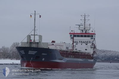
CEMSEA III
Cement Carrier
Current Trip
FILOV
| Time Travelled | 2 days |
|---|---|
| Remaining Time | --- |
| Distance Travelled | 330.24 nm |
| Remaining Distance | --- |
| AVG Speed | 9.4 Noeuds |
| MAX Speed | 10.6 Noeuds |
| AVG Wind | 5.1 knots |
| MAX Wind | 17.2 knots |
| MIN Temp | 2.1°C / 35.78°F |
| MAX Temp | 5.4°C / 41.72°F |
| Tirant d eau | 6.3 m |
| Position reçue | 1 m depuis |
Current Position
| Longitude | 26.26003° |
|---|---|
| Latitude | 60.40948° |
| Etat | Moored |
| Vitesse | |
| Parcours | 314° |
| Zone | Gulf of Finland |
| Station | T-AIS |
| Position reçue | 1 m depuis |
Info
Information
The current position of CEMSEA III is in Gulf of Finland with coordinates 60.40948° / 26.26003° as reported on 2024-04-18 02:48 by AIS to our vessel tracker app. The vessel's current speed is 0 Noeuds
The vessel CEMSEA III (IMO: 9195925, MMSI: 212209000) is a Cement Carrier that was built in 2001 ( 23 Age ). It's sailing under the flag of [CY] Cyprus.
In this page you can find informations about the vessels current position, last detected port calls, and current voyage information. If the vessels is not in coverage by AIS you will find the latest position.
The current position of CEMSEA III is detected by our AIS receivers and we are not responsible for the reliability of the data. The last position was recorded while the vessel was in Coverage by the Ais receivers of our vessel tracking app.
The current draught of CEMSEA III as reported by AIS is 6.3 meters
Weather
| Temperature | -1.9°C / 28.58°F |
|---|---|
| Wind Speed | 5 knots |
| Direction | 49° NE |
| Pressure | 1012.4 hPa |
| Humidity | 77.7 % |
| Cloud Coverage | 53 % |
Featured Company
Last Port Calls
| Port | Arrival | Departure | Time In Port |
|---|---|---|---|
| 2024-04-13 00:46 | 2024-04-15 08:10 | 2 d | |
| 2024-04-10 18:58 | 2024-04-11 20:55 | 1 d | |
| 2024-04-08 11:33 | 2024-04-09 17:09 | 1 d | |
| 2024-04-06 08:11 | 2024-04-07 17:59 | 1 d | |
| 2024-04-03 17:54 | 2024-04-05 08:15 | 1 d | |
| 2024-03-28 17:44 | 2024-03-29 23:37 | 1 d | |
| 2024-03-25 21:29 | 2024-03-27 10:04 | 1 d | |
| 2024-03-22 06:29 | 2024-03-24 08:59 | 2 d | |
| 2024-03-19 12:28 | 2024-03-20 13:32 | 1 d | |
| 2024-03-15 04:39 | 2024-03-16 20:05 | 1 d |
Last Trips
| Origin | Departure | Destination | Arrival | Distance | |
|---|---|---|---|---|---|
| 2024-04-11 23:55 | 2024-04-13 03:46 | 252.55 nm | |||
| 2024-04-09 20:09 | 2024-04-10 21:58 | 251.99 nm | |||
| 2024-04-07 19:59 | 2024-04-08 14:33 | 186.71 nm | |||
| 2024-04-05 11:15 | 2024-04-06 10:11 | 239.17 nm | |||
| 2024-03-30 01:37 | 2024-04-03 20:54 | 712.25 nm | |||
| 2024-03-27 11:04 | 2024-03-28 19:44 | 344.54 nm | |||
| 2024-03-24 09:59 | 2024-03-25 22:29 | 361.34 nm | |||
| 2024-03-20 14:32 | 2024-03-22 07:29 | 458.02 nm | |||
| 2024-03-16 21:05 | 2024-03-19 13:28 | 467.94 nm | |||
| 2024-03-14 04:08 | 2024-03-15 05:39 | 207.82 nm |
Events
| Heure | Evenement | Détails | Position/ Destination | Info |
|---|---|---|---|---|
| 2024-04-16 17:48 | Etat Changé | Moored Under way using engine |
60.40948 / 26.26004
FILOV
|
Vitesse: Parcours: 314° |
| 2024-04-16 17:46 | Arret | 21.14 nm, West of KOTKA |
60.40948 / 26.26008
FILOV
|
Vitesse: 0.2 kn Parcours: 313° |
| 2024-04-16 15:10 | Tirant d'eau modifié | 6.3 6.4 |
60.08226 / 26.22018
FILOV
|
Vitesse: 10 kn Parcours: 38.9° |
| 2024-04-16 15:04 | Etat Changé | Under way using engine Default |
60.06994 / 26.20012
FILOV
|
Vitesse: 10.2 kn Parcours: 39° |
| 2024-04-16 14:48 | Dans la zone couverte |
60.07249 / 26.20417
Gulf of Finland
FILOV
|
Vitesse: 10.1 kn Parcours: 39.2° |
|
| 2024-04-16 13:15 | Etat Changé | Default Under way using engine |
59.87392 / 25.75317
FILOV
|
Vitesse: 10.2 kn Parcours: 79.6° |
| 2024-04-16 13:09 | Detecté en mer | Finnish part of the Gulf of Finland |
59.87056 / 25.71840
Gulf of Finland
FILOV
|
Vitesse: 10.2 kn Parcours: 79.6° |
| 2024-04-16 13:09 | Hors de la zone couverte |
59.87056 / 25.71840
Gulf of Finland
FILOV
|
Vitesse: 10.2 kn Parcours: 79.6° |
|
| 2024-04-16 12:37 | Etat Changé | Under way using engine Default |
59.85423 / 25.54627
FILOV
|
Vitesse: 10.1 kn Parcours: 79° |
| 2024-04-16 12:19 | Etat Changé | Default Under way using engine |
59.84434 / 25.44740
FILOV
|
Vitesse: 9.9 kn Parcours: 79° |