
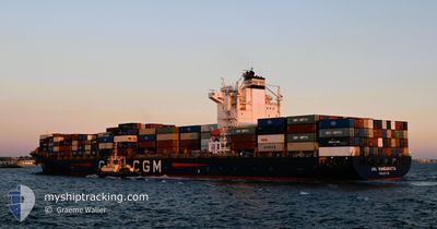
ANL WANGARATTA
Container Ship
Current Trip
| Time Travelled | 7 h, 10 mins |
|---|---|
| Remaining Time | --- |
| Distance Travelled | 69.52 nm |
| Remaining Distance | 110.32 nm |
| AVG Speed | 15.1 Noeuds |
| MAX Speed | 18 Noeuds |
| AVG Wind | 17.3 knots |
| MAX Wind | 20.7 knots |
| MIN Temp | 10.2°C / 50.36°F |
| MAX Temp | 12.2°C / 53.96°F |
| Tirant d eau | 9.7 m |
| Position reçue | 5 h, 51 m depuis |
Current Position
| Longitude | --- |
|---|---|
| Latitude | --- |
| Etat | Under way using engine |
| Vitesse | 17.8 Noeuds |
| Parcours | 134.3° |
| Zone | Philippine Sea |
| Station | T-AIS |
| Position reçue | 5 h, 51 m depuis |
Info
Information
The current position of ANL WANGARATTA is in Philippine Sea with coordinates 34.65062° / 136.84272° as reported on 2025-12-09 12:07 by AIS to our vessel tracker app. The vessel's current speed is 17.8 Noeuds and is heading at the port of OMAEZAKI. The estimated time of arrival as calculated by MyShipTracking vessel tracking app is 2025-12-07 07:00 LT
The vessel ANL WANGARATTA (IMO: 9334167, MMSI: 215167000) is a Container Ship that was built in 2008 ( 17 Age ). It's sailing under the flag of [MT] Malta.
In this page you can find informations about the vessels current position, last detected port calls, and current voyage information. If the vessels is not in coverage by AIS you will find the latest position.
The current position of ANL WANGARATTA is detected by our AIS receivers and we are not responsible for the reliability of the data. The last position was recorded while the vessel was in Coverage by the Ais receivers of our vessel tracking app.
The current draught of ANL WANGARATTA as reported by AIS is 9.7 meters
Weather
| Temperature | 10.8°C / 51.44°F |
|---|---|
| Wind Speed | 8 knots |
| Direction | 331° NNW |
| Pressure | 1023.6 hPa |
| Humidity | 58.6 % |
| Cloud Coverage | 2 % |
Featured Company
Last Port Calls
| Port | Arrival | Departure | Time In Port |
|---|---|---|---|
| 2025-12-09 00:01 | 2025-12-09 19:49 | 19 h | |
| 2025-12-08 07:33 | 2025-12-08 16:17 | 8 h | |
| 2025-12-07 07:45 | 2025-12-07 20:37 | 12 h | |
| 2025-12-05 21:40 | 2025-12-06 17:24 | 19 h | |
| 2025-12-03 07:11 | 2025-12-04 05:19 | 22 h | |
| 2025-11-26 10:40 | 2025-11-28 13:33 | 2 d | |
| 2025-11-20 10:37 | 2025-11-21 10:47 | 1 d | |
| 2025-11-12 07:03 | 2025-11-13 00:27 | 17 h | |
| 2025-11-10 17:00 | 2025-11-11 13:57 | 20 h | |
| 2025-11-10 07:26 | 2025-11-10 16:24 | 8 h |
Last Trips
| Origin | Departure | Destination | Arrival | Distance | |
|---|---|---|---|---|---|
| 2025-12-08 16:17 | 2025-12-09 00:01 | 13.74 nm | |||
| 2025-12-07 20:37 | 2025-12-08 07:33 | 109.72 nm | |||
| 2025-12-06 17:24 | 2025-12-07 07:45 | 122.10 nm | |||
| 2025-12-04 05:19 | 2025-12-05 21:40 | 16.37 nm | |||
| 2025-11-28 13:33 | 2025-12-03 07:11 | 1789.71 nm | |||
| 2025-11-21 10:47 | 2025-11-26 10:40 | 1345.86 nm | |||
| 2025-11-13 00:27 | 2025-11-20 10:37 | 2723.55 nm | |||
| 2025-11-11 13:57 | 2025-11-12 07:03 | 245.56 nm | |||
| 2025-11-10 16:24 | 2025-11-10 17:00 | 8.62 nm | |||
| 2025-11-09 19:30 | 2025-11-10 07:26 | 115.62 nm |
Events
| Heure | Evenement | Détails | Position/ Destination | Info |
|---|---|---|---|---|
| 2025-12-09 12:13 | Etat Changé | Default Under way using engine |
34.63319 / 136.87144
JP OMZ
|
Vitesse: 17.8 kn Parcours: 134.3° |
| 2025-12-09 12:07 | Etat Changé | Under way using engine Default |
34.65062 / 136.84272
JP OMZ
|
Vitesse: 17.8 kn Parcours: 135° |
| 2025-12-09 12:07 | Hors de la zone couverte |
34.65062 / 136.84272
Philippine Sea
|
Vitesse: 17.8 kn Parcours: 134.3° |
|
| 2025-12-09 11:17 | Etat Changé | Default Under way using engine |
34.87884 / 136.75427
JP OMZ
|
Vitesse: 17.1 kn Parcours: 204.3° |
| 2025-12-09 11:07 | Etat Changé | Under way using engine Default |
34.92728 / 136.76238
JP OMZ
|
Vitesse: 17.6 kn Parcours: 218° |
| 2025-12-09 11:05 | Etat Changé | Default Under way using engine |
34.93415 / 136.76901
JP OMZ
|
Vitesse: 14.4 kn Parcours: 213.6° |
| 2025-12-09 10:56 | Etat Changé | Under way using engine Default |
34.96570 / 136.79826
JP OMZ
|
Vitesse: 13.3 kn Parcours: 214° |
| 2025-12-09 10:49 | Dans la zone couverte |
34.96570 / 136.79826
Philippine Sea
|
Vitesse: 14.4 kn Parcours: 213.6° |
|
| 2025-12-09 10:49 | PORT DE DEPART |
|
34.98817 / 136.81622
JP OMZ
|
Vitesse: 12.3 kn Parcours: 215° |
| 2025-12-09 10:37 | Démarrage |
35.01918 / 136.83546
[JP] NAGOYA
|
Vitesse: 7.6 kn Parcours: 160° |