
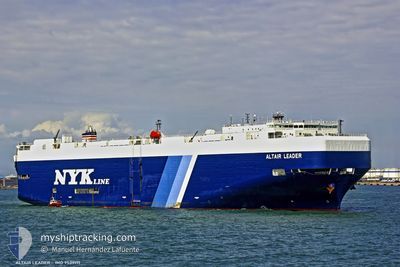
ALTAIR LEADER
Vehicles Carrier
Current Trip
| Trip Time | 1 day |
|---|---|
| Trip Distance | 250.39 nm |
| AVG Speed | 10 Noeuds |
| MAX Speed | 14.6 Noeuds |
| Tirant d eau | 8.3 m |
| AVG Wind | 9.6 knots |
| MAX Wind | 21.5 knots |
| MIN Temp | 11.1°C / 51.98°F |
| MAX Temp | 17.8°C / 64.04°F |
| Position reçue | 12 h, 52 m depuis |
Current Position
| Longitude | --- |
|---|---|
| Latitude | --- |
| Etat | Under way using engine |
| Vitesse | 1.9 Noeuds |
| Parcours | 36° |
| Zone | North Pacific Ocean |
| Station | T-AIS |
| Position reçue | 12 h, 52 m depuis |
Info
Information
The current position of ALTAIR LEADER is in North Pacific Ocean with coordinates 36.28693° / 140.85581° as reported on 2024-11-22 18:27 by AIS to our vessel tracker app. The vessel's current speed is 1.9 Noeuds and is currently inside the port of HITACHINAKA.
The vessel ALTAIR LEADER (IMO: 9539171, MMSI: 432817000) is a Vehicles Carrier that was built in 2011 ( 13 Age ). It's sailing under the flag of [JP] Japan.
In this page you can find informations about the vessels current position, last detected port calls, and current voyage information. If the vessels is not in coverage by AIS you will find the latest position.
The current position of ALTAIR LEADER is detected by our AIS receivers and we are not responsible for the reliability of the data. The last position was recorded while the vessel was in Coverage by the Ais receivers of our vessel tracking app.
The current draught of ALTAIR LEADER as reported by AIS is 8.3 meters
Weather
| Temperature | 10°C / 50°F |
|---|---|
| Wind Speed | 8 knots |
| Direction | 350° N |
| Pressure | 1018.8 hPa |
| Humidity | 55.5 % |
| Cloud Coverage | 6 % |
Featured Company
Last Port Calls
| Port | Arrival | Departure | Time In Port |
|---|---|---|---|
| 2024-11-23 06:20 | |||
| 2024-11-20 10:08 | 2024-11-21 16:04 | 1 d | |
| 2024-10-15 04:56 | 2024-10-15 12:51 | 7 h | |
| 2024-10-14 06:04 | 2024-10-14 16:20 | 10 h | |
| 2024-10-12 19:26 | 2024-10-13 17:44 | 22 h | |
| 2024-10-10 20:05 | 2024-10-11 13:32 | 17 h | |
| 2024-10-07 20:16 | 2024-10-08 14:12 | 17 h | |
| 2024-09-11 07:01 | 2024-09-11 19:37 | 12 h | |
| 2024-09-10 07:37 | 2024-09-10 17:23 | 9 h | |
| 2024-09-09 06:17 | 2024-09-09 14:44 | 8 h |
Last Trips
| Origin | Departure | Destination | Arrival | Distance | |
|---|---|---|---|---|---|
| 2024-11-21 16:04 | 2024-11-23 06:20 | 250.39 nm | |||
| 2024-10-15 12:51 | 2024-11-20 10:08 | 10787.04 nm | |||
| 2024-10-14 16:20 | 2024-10-15 04:56 | 118.19 nm | |||
| 2024-10-13 17:44 | 2024-10-14 06:04 | 175.45 nm | |||
| 2024-10-11 13:32 | 2024-10-12 19:26 | 308.65 nm | |||
| 2024-10-08 14:12 | 2024-10-10 20:05 | 692.98 nm | |||
| 2024-09-11 19:37 | 2024-10-07 20:16 | 9521.93 nm | |||
| 2024-09-10 17:23 | 2024-09-11 07:01 | 114.61 nm | |||
| 2024-09-09 14:44 | 2024-09-10 07:37 | 182.35 nm | |||
| 2024-08-01 16:40 | 2024-09-09 06:17 | 7314.82 nm |
Events
| Heure | Evenement | Détails | Position/ Destination | Info |
|---|---|---|---|---|
| 2024-11-22 21:52 | Arret |
36.42742 / 140.61746
[JP] HITACHINAKA
|
Vitesse: Parcours: 90° |
|
| 2024-11-22 21:20 | Port d'arrivée |
|
36.42099 / 140.63286
[JP] HITACHINAKA
|
Vitesse: 11.7 kn Parcours: 345° |
| 2024-11-22 18:33 | Etat Changé | Default Under way using engine |
36.28801 / 140.85745
JP HIC
|
Vitesse: 1.9 kn Parcours: 36° |
| 2024-11-22 18:27 | Etat Changé | Under way using engine Default |
36.28693 / 140.85581
JP HIC
|
Vitesse: 1.8 kn Parcours: 64° |
| 2024-11-22 18:27 | Dans la zone couverte |
36.28693 / 140.85581
North Pacific Ocean
JP HIC
|
Vitesse: 1.9 kn Parcours: 92.2° |
|
| 2024-11-22 18:27 | Hors de la zone couverte |
36.28693 / 140.85581
North Pacific Ocean
JP HIC
|
Vitesse: 1.9 kn Parcours: 92.2° |
|
| 2024-11-22 11:12 | Démarrage | 8.22 nm, East of NAKAMINATO |
36.33057 / 140.76900
JP HIC
|
Vitesse: 3.4 kn Parcours: 101° |
| 2024-11-22 06:57 | Arret | 9.72 nm, East of NAKAMINATO |
36.34231 / 140.80006
JP HIC
|
Vitesse: 0.2 kn Parcours: 56° |
| 2024-11-22 06:16 | Démarrage | 9.53 nm, East of NAKAMINATO |
36.31210 / 140.79344
JP HIC
|
Vitesse: 3.7 kn Parcours: 358° |
| 2024-11-22 05:48 | Arret | 9.83 nm, East of NAKAMINATO |
36.31126 / 140.79968
JP HIC
|
Vitesse: 0.2 kn Parcours: 132° |