
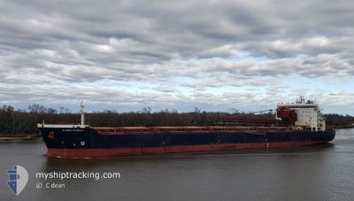
ALGOMA INTEGRITY
Self Discharging Bulk Carrier
Current Trip
| Trip Time | 2 days |
|---|---|
| Trip Distance | 499.41 nm |
| AVG Speed | 10 Noeuds |
| MAX Speed | 14.5 Noeuds |
| Tirant d eau | 10 m |
| AVG Wind | 8.4 knots |
| MAX Wind | 14 knots |
| MIN Temp | 13.2°C / 55.76°F |
| MAX Temp | 22°C / 71.6°F |
| Position reçue | 3 m depuis |
Current Position
| Longitude | --- |
|---|---|
| Latitude | --- |
| Etat | Moored |
| Vitesse | |
| Parcours | 90° |
| Zone | North Atlantic Ocean |
| Station | T-AIS |
| Position reçue | 3 m depuis |
Info
Information
The current position of ALGOMA INTEGRITY is in North Atlantic Ocean with coordinates 28.40901° / -80.60903° as reported on 2025-02-26 23:53 by AIS to our vessel tracker app. The vessel's current speed is 0 Noeuds and is currently inside the port of CAPE CANAVERAL.
The vessel ALGOMA INTEGRITY (IMO: 9405162, MMSI: 311000808) is a Self Discharging Bulk Carrier that was built in 2009 ( 16 Age ). It's sailing under the flag of [BS] Bahamas.
In this page you can find informations about the vessels current position, last detected port calls, and current voyage information. If the vessels is not in coverage by AIS you will find the latest position.
The current position of ALGOMA INTEGRITY is detected by our AIS receivers and we are not responsible for the reliability of the data. The last position was recorded while the vessel was in Coverage by the Ais receivers of our vessel tracking app.
The current draught of ALGOMA INTEGRITY as reported by AIS is 10 meters
Weather
| Temperature | 20.5°C / 68.9°F |
|---|---|
| Wind Speed | 9 knots |
| Direction | 111° ESE |
| Pressure | 1016.8 hPa |
| Humidity | 79.1 % |
| Cloud Coverage | --- |
Featured Company
Last Port Calls
| Port | Arrival | Departure | Time In Port |
|---|---|---|---|
| 2025-02-26 18:02 | |||
| 2025-02-22 15:55 | 2025-02-23 19:23 | 1 d | |
| 2025-02-19 17:36 | 2025-02-20 16:45 | 23 h | |
| 2025-02-15 22:59 | 2025-02-17 01:11 | 1 d | |
| 2025-02-12 08:27 | 2025-02-13 06:45 | 22 h | |
| 2025-02-11 00:27 | 2025-02-11 17:51 | 17 h | |
| 2025-02-06 08:03 | 2025-02-07 05:43 | 21 h | |
| 2025-02-05 00:54 | 2025-02-05 20:36 | 19 h | |
| 2025-02-03 09:19 | 2025-02-04 13:39 | 1 d | |
| 2025-01-29 19:46 | 2025-01-30 19:39 | 23 h |
Most Visited Ports (Last year)
| Port | Arrivals | |
|---|---|---|
| 6 | ||
| 6 | ||
| 4 | ||
| 4 | ||
| 4 | ||
| 2 |
Last Trips
| Origin | Departure | Destination | Arrival | Distance | |
|---|---|---|---|---|---|
| 2025-02-23 19:23 | 2025-02-26 18:02 | 499.41 nm | |||
| 2025-02-20 16:45 | 2025-02-22 15:55 | 561.31 nm | |||
| 2025-02-17 01:11 | 2025-02-19 17:36 | 575.04 nm | |||
| 2025-02-13 06:45 | 2025-02-15 22:59 | 788.75 nm | |||
| 2025-02-11 17:51 | 2025-02-12 08:27 | 86.79 nm | |||
| 2025-02-07 05:43 | 2025-02-11 00:27 | 772.37 nm | |||
| 2025-02-05 20:36 | 2025-02-06 08:03 | 123.75 nm | |||
| 2025-02-04 13:39 | 2025-02-05 00:54 | 121.65 nm | |||
| 2025-01-30 19:39 | 2025-02-03 09:19 | 1055.75 nm | |||
| 2025-01-25 07:03 | 2025-01-29 19:46 | 1059.43 nm |
Events
| Heure | Evenement | Détails | Position/ Destination | Info |
|---|---|---|---|---|
| 2025-02-26 23:36 | Etat Changé | Moored Under way using engine |
28.40903 / -80.60902
[US] CAPE CANAVERAL
|
Vitesse: 0.1 kn Parcours: 90° |
| 2025-02-26 23:26 | Arret |
28.40924 / -80.60908
[US] CAPE CANAVERAL
|
Vitesse: 0.3 kn Parcours: 88° |
|
| 2025-02-26 23:02 | Port d'arrivée |
|
28.40962 / -80.58867
[US] CAPE CANAVERAL
|
Vitesse: 6.9 kn Parcours: 271.5° |
| 2025-02-26 22:34 | Tirant d'eau modifié | 10 8 |
28.36661 / -80.51428
US PCV
|
Vitesse: 9.4 kn Parcours: 298.2° |
| 2025-02-26 22:34 | Changement de destination | US PCV BSFPO |
28.36661 / -80.51428
US PCV
|
Vitesse: 9.4 kn Parcours: 298.2° |
| 2025-02-26 22:34 | Changement d'ETA | 2025/02/26 23:00 2025/02/23 23:00 |
28.36661 / -80.51428
US PCV
|
Vitesse: 9.4 kn Parcours: 298.2° |
| 2025-02-26 21:44 | Etat Changé | Under way using engine Default |
28.33759 / -80.35196
BSFPO
|
Vitesse: 12.1 kn Parcours: 269° |
| 2025-02-26 21:44 | Dans la zone couverte |
28.33658 / -80.35626
North Atlantic Ocean
|
Vitesse: 6.2 kn Parcours: 274.8° |
|
| 2025-02-26 15:58 | Etat Changé | Default Under way using engine |
29.04587 / -80.03235
BSFPO
|
Vitesse: 8.6 kn Parcours: 159.1° |
| 2025-02-26 15:45 | Hors de la zone couverte |
29.07530 / -80.04554
North Atlantic Ocean
|
Vitesse: 8.6 kn Parcours: 159.1° |