
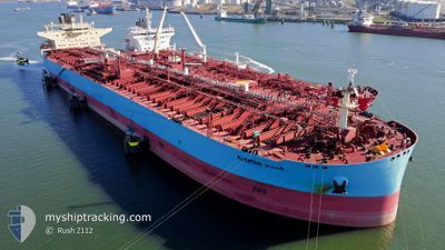
AL KHTAM
Tanker
Current Trip
| Time Travelled | 34 days |
|---|---|
| Remaining Time | --- |
| Distance Travelled | 9976.45 nm |
| Remaining Distance | --- |
| AVG Speed | 12.1 Noeuds |
| MAX Speed | 17 Noeuds |
| AVG Wind | 13.1 knots |
| MAX Wind | 32 knots |
| MIN Temp | 18.3°C / 64.94°F |
| MAX Temp | 29.3°C / 84.74°F |
| Tirant d eau | 14.6 m |
| Position reçue | 14 m depuis |
Current Position
| Longitude | -16.16335° |
|---|---|
| Latitude | 26.26508° |
| Etat | Under way using engine |
| Vitesse | 12.8 Noeuds |
| Parcours | 29.4° |
| Zone | North Atlantic Ocean |
| Station | T-AIS |
| Position reçue | 14 m depuis |
Info
Information
The current position of AL KHTAM is in North Atlantic Ocean with coordinates 26.26508° / -16.16335° as reported on 2024-04-17 19:20 by AIS to our vessel tracker app. The vessel's current speed is 12.8 Noeuds and is heading at the port of ROTTERDAM. The estimated time of arrival as calculated by MyShipTracking vessel tracking app is 2024-04-24 09:00 LT
The vessel AL KHTAM (IMO: 9823534, MMSI: 636020895) is a Tanker It's sailing under the flag of [LR] Liberia.
In this page you can find informations about the vessels current position, last detected port calls, and current voyage information. If the vessels is not in coverage by AIS you will find the latest position.
The current position of AL KHTAM is detected by our AIS receivers and we are not responsible for the reliability of the data. The last position was recorded while the vessel was in Coverage by the Ais receivers of our vessel tracking app.
The current draught of AL KHTAM as reported by AIS is 14.6 meters
Weather
| Temperature | 21.4°C / 70.52°F |
|---|---|
| Wind Speed | 7 knots |
| Direction | 16° NNE |
| Pressure | 1014.9 hPa |
| Humidity | 76.6 % |
| Cloud Coverage | 100 % |
Featured Company
Events
| Heure | Evenement | Détails | Position/ Destination | Info |
|---|---|---|---|---|
| 2024-04-17 19:27 | Etat Changé | Default Under way using engine |
26.28670 / -16.14943
ROTTERDAM FOR ORDERS
|
Vitesse: 12.8 kn Parcours: 29.4° |
| 2024-04-17 17:32 | Etat Changé | Under way using engine Default |
25.91922 / -16.37076
ROTTERDAM FOR ORDERS
|
Vitesse: 12.8 kn Parcours: 30° |
| 2024-04-17 17:17 | Dans la zone couverte |
25.92674 / -16.36641
North Atlantic Ocean
ROTTERDAM FOR ORDERS
|
Vitesse: 13 kn Parcours: 28.7° |
|
| 2024-04-17 16:39 | Etat Changé | Default Under way using engine |
25.75016 / -16.47112
ROTTERDAM FOR ORDERS
|
Vitesse: 13.1 kn Parcours: 29.1° |
| 2024-04-17 16:31 | Etat Changé | Under way using engine Default |
25.72366 / -16.48709
ROTTERDAM FOR ORDERS
|
Vitesse: 13.1 kn Parcours: 29° |
| 2024-04-17 16:31 | Hors de la zone couverte |
25.72366 / -16.48709
North Atlantic Ocean
ROTTERDAM FOR ORDERS
|
Vitesse: 13.1 kn Parcours: 29.1° |
|
| 2024-04-17 16:19 | Etat Changé | Default Under way using engine |
25.68618 / -16.50962
ROTTERDAM FOR ORDERS
|
Vitesse: 13.3 kn Parcours: 29.6° |
| 2024-04-17 15:55 | Etat Changé | Under way using engine Default |
25.61002 / -16.55824
ROTTERDAM FOR ORDERS
|
Vitesse: 13.1 kn Parcours: 32° |
| 2024-04-17 15:38 | Etat Changé | Default Under way using engine |
25.53660 / -16.60519
ROTTERDAM FOR ORDERS
|
Vitesse: 13.1 kn Parcours: 31.6° |
| 2024-04-17 15:22 | Etat Changé | Under way using engine Default |
25.50451 / -16.62624
ROTTERDAM FOR ORDERS
|
Vitesse: 13 kn Parcours: 30° |