
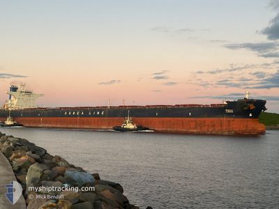
ADONIS
Bulk Carrier
Current Trip
| Time Travelled | 5 days |
|---|---|
| Remaining Time | --- |
| Distance Travelled | 50.80 nm |
| Remaining Distance | --- |
| AVG Speed | 11.1 Noeuds |
| MAX Speed | 13.2 Noeuds |
| AVG Wind | 16.3 knots |
| MAX Wind | 30 knots |
| MIN Temp | 0.3°C / 32.54°F |
| MAX Temp | 12.6°C / 54.68°F |
| Tirant d eau | 16.1 m |
| Position reçue | 2025-10-19 05:49 |
Current Position
| Longitude | --- |
|---|---|
| Latitude | --- |
| Etat | Under way using engine |
| Vitesse | 11.8 Noeuds |
| Parcours | 330.8° |
| Zone | Bismarck Sea |
| Station | T-AIS |
| Position reçue | 2025-10-19 05:49 |
Info
Information
The current position of ADONIS is in Bismarck Sea with coordinates -1.31004° / 145.19906° as reported on 2025-10-19 05:49 by AIS to our vessel tracker app. The vessel's current speed is 11.8 Noeuds
The vessel ADONIS (IMO: 9320362, MMSI: 351665000) is a Bulk Carrier that was built in 2006 ( 19 Age ). It's sailing under the flag of [PA] Panama.
In this page you can find informations about the vessels current position, last detected port calls, and current voyage information. If the vessels is not in coverage by AIS you will find the latest position.
The current position of ADONIS is detected by our AIS receivers and we are not responsible for the reliability of the data. The last position was recorded while the vessel was in Coverage by the Ais receivers of our vessel tracking app.
The current draught of ADONIS as reported by AIS is 16.1 meters
Weather
| Temperature | 12.6°C / 54.68°F |
|---|---|
| Wind Speed | 14 knots |
| Direction | 225° SW |
| Pressure | 1019.5 hPa |
| Humidity | 79.4 % |
| Cloud Coverage | 79 % |
Featured Company
Events
| Heure | Evenement | Détails | Position/ Destination | Info |
|---|---|---|---|---|
| 2025-12-02 08:54 | Arret | 19.45 nm, West of SEOIN |
36.05094 / 126.11186
KR BOR
|
Vitesse: 0.2 kn Parcours: 4° |
| 2025-12-02 05:44 | Démarrage | 0.47 nm, South West of BORYEONG |
36.39005 / 126.47546
KR BOR
|
Vitesse: 3.2 kn Parcours: 247° |
| 2025-12-02 05:43 | PORT DE DEPART |
|
36.39005 / 126.47546
KR BOR
|
Vitesse: Parcours: -1° |
| 2025-11-29 04:42 | Port d'arrivée |
|
36.38937 / 126.47832
[KR] BORYEONG
|
Vitesse: Parcours: -1° |
| 2025-11-29 04:16 | Arret | 0.52 nm, South West of BORYEONG |
36.38833 / 126.47667
KR BOR
|
Vitesse: Parcours: -1° |
| 2025-11-29 03:16 | Démarrage | 2.95 nm, South West of DAECHEONHANG |
36.30667 / 126.45667
KR BOR
|
Vitesse: 4 kn Parcours: -1° |
| 2025-11-29 01:38 | Arret | 3.34 nm, South West of DAECHEONHANG |
36.30098 / 126.45146
KR BOR
|
Vitesse: 0.3 kn Parcours: 63° |
| 2025-11-28 22:22 | Démarrage | 20.98 nm, West of SEOIN |
36.05258 / 126.07921
KR BOR
|
Vitesse: 7.9 kn Parcours: 52° |