
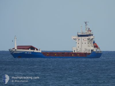
Unkown Name
General Cargo
Current Trip
| Time Travelled | 9 days |
|---|---|
| Remaining Time | --- |
| Distance Travelled | 1075.06 nm |
| Remaining Distance | --- |
| AVG Speed | 7.4 Noeuds |
| MAX Speed | 7.4 Noeuds |
| AVG Wind | 7.7 knots |
| MAX Wind | 31 knots |
| MIN Temp | 16.4°C / 61.52°F |
| MAX Temp | 27.1°C / 80.78°F |
| Tirant d eau | 6.1 m |
| Position reçue | 17 h, 21 m depuis |
Current Position
| Longitude | --- |
|---|---|
| Latitude | --- |
| Etat | Under way using engine |
| Vitesse | 9.4 Noeuds |
| Parcours | 352.9° |
| Zone | Black Sea |
| Station | T-AIS |
| Position reçue | 17 h, 21 m depuis |
Info
Information
The current position of Unkown Name is in Black Sea with coordinates 41.39450° / 29.20389° as reported on 2024-09-29 04:56 by AIS to our vessel tracker app. The vessel's current speed is 9.4 Noeuds and is heading at the port of GALATI. The estimated time of arrival as calculated by MyShipTracking vessel tracking app is 2024-09-26 06:00 LT
The vessel Unkown Name (IMO: 8913057, MMSI: 671436000) is a General Cargo that was built in 1991 ( 33 Age ). It's sailing under the flag of [TG] Togo.
In this page you can find informations about the vessels current position, last detected port calls, and current voyage information. If the vessels is not in coverage by AIS you will find the latest position.
The current position of Unkown Name is detected by our AIS receivers and we are not responsible for the reliability of the data. The last position was recorded while the vessel was in Coverage by the Ais receivers of our vessel tracking app.
The current draught of Unkown Name as reported by AIS is 6.1 meters
Weather
| Temperature | 16.2°C / 61.16°F |
|---|---|
| Wind Speed | 27 knots |
| Direction | 331° NNW |
| Pressure | 1008.1 hPa |
| Humidity | 85.4 % |
| Cloud Coverage | 100 % |
Featured Company
Last Port Calls
| Port | Arrival | Departure | Time In Port |
|---|---|---|---|
| 2024-09-12 16:49 | 2024-09-20 17:48 | 8 d | |
| 2024-09-07 23:45 | 2024-09-11 00:29 | 3 d | |
| 2024-08-16 09:23 | 2024-08-29 17:21 | 13 d | |
| 2024-08-06 06:45 | 2024-08-08 15:03 | 2 d | |
| 2024-07-26 18:27 | 2024-07-28 06:30 | 1 d | |
| 2024-07-19 22:25 | 2024-07-22 22:30 | 3 d | |
| 2024-07-04 17:05 |
Most Visited Ports (Last year)
| Port | Arrivals | |
|---|---|---|
| 7 | ||
| 4 | ||
| 4 | ||
| 3 | ||
| 1 | ||
| 1 |
Last Trips
| Origin | Departure | Destination | Arrival | Distance | |
|---|---|---|---|---|---|
| 2024-09-11 02:29 | 2024-09-12 19:49 | 397.20 nm | |||
| 2024-08-29 19:21 | 2024-09-08 01:45 | 1270.26 nm | |||
| 2024-08-08 17:03 | 2024-08-16 11:23 | 198.32 nm | |||
| 2024-07-28 09:30 | 2024-08-06 08:45 | 1231.45 nm | |||
| 2024-07-23 00:30 | 2024-07-26 21:27 | 631.61 nm | |||
| 2024-07-04 19:05 | 2024-07-20 00:25 | 1336.02 nm |
Events
| Heure | Evenement | Détails | Position/ Destination | Info |
|---|---|---|---|---|
| 2024-09-29 05:01 | Etat Changé | Default Under way using engine |
41.40771 / 29.20053
ROGALATI
|
Vitesse: 9.4 kn Parcours: 352.9° |
| 2024-09-29 04:56 | Hors de la zone couverte |
41.39450 / 29.20389
Black Sea
|
Vitesse: 9.4 kn Parcours: 352.9° |
|
| 2024-09-29 04:48 | Etat Changé | Under way using engine Default |
41.37271 / 29.20663
ROGALATI
|
Vitesse: 9.5 kn Parcours: 359° |
| 2024-09-29 04:41 | Etat Changé | Default Under way using engine |
41.35562 / 29.20789
ROGALATI
|
Vitesse: 9.7 kn Parcours: 3.3° |
| 2024-09-29 03:53 | Changement de zone | Turkish part of the Black Sea Turkish part of the Sea of Marmara |
41.23474 / 29.13988
Black Sea
|
Vitesse: 10.1 kn Parcours: 28.9° |
| 2024-09-28 23:34 | Démarrage | 8.33 nm, South of YESILKOY |
40.81660 / 28.83139
ROGALATI
|
Vitesse: 5.6 kn Parcours: 32.6° |
| 2024-09-28 23:33 | Arret | 8.42 nm, South of YESILKOY |
40.81510 / 28.83002
ROGALATI
|
Vitesse: Parcours: 36° |
| 2024-09-28 22:48 | Etat Changé | Under way using engine Not under command |
40.76903 / 28.78527
ROGALATI
|
Vitesse: 0.5 kn Parcours: 90° |
| 2024-09-28 14:49 | Etat Changé | Not under command Under way using engine |
40.83626 / 28.90769
ROGALATI
|
Vitesse: 2.2 kn Parcours: 156° |
| 2024-09-28 13:53 | Démarrage | 1.22 nm, South East of ZEYTINBURNU |
40.96020 / 28.90326
ROGALATI
|
Vitesse: 4.2 kn Parcours: 139° |