
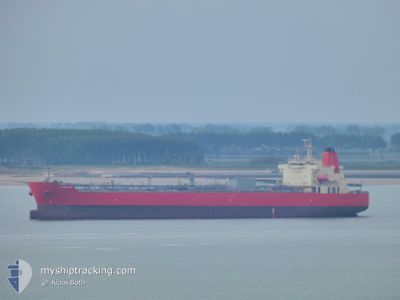
ZANDOLIE
Tanker
Current Trip
| Time Travelled | 9 days |
|---|---|
| Remaining Time | 4 days |
| Distance Travelled | 2557.16 nm |
| Remaining Distance | 1382.38 nm |
| AVG Speed | 10.3 Knots |
| MAX Speed | 16.9 Knots |
| AVG Wind | 22.7 knots |
| MAX Wind | 44 knots |
| MIN Temp | 8°C / 46.4°F |
| MAX Temp | 19.1°C / 66.38°F |
| Dybgang | 11.3 m |
| Position Modtaget | 2 d siden |
Current Position
| Longitude | -30.57148° |
|---|---|
| Latitude | 38.82148° |
| Status | Under way using engine |
| Fart | 13.4 Knots |
| Kurs | 226.1° |
| Område | North Atlantic Ocean |
| Station | T-AIS |
| Position Modtaget | 2 d siden |
Info
Information
The current position of ZANDOLIE is in North Atlantic Ocean with coordinates 38.82148° / -30.57148° as reported on 2024-04-14 00:37 by AIS to our vessel tracker app. The vessel's current speed is 13.4 Knots and is heading at the port of SAN JUAN. The estimated time of arrival as calculated by MyShipTracking vessel tracking app is 2024-04-21 04:08 LT
The vessel ZANDOLIE (IMO: 9893163, MMSI: 357558000) is a Tanker It's sailing under the flag of [PA] Panama.
In this page you can find informations about the vessels current position, last detected port calls, and current voyage information. If the vessels is not in coverage by AIS you will find the latest position.
The current position of ZANDOLIE is detected by our AIS receivers and we are not responsible for the reliability of the data. The last position was recorded while the vessel was in Coverage by the Ais receivers of our vessel tracking app.
The current draught of ZANDOLIE as reported by AIS is 11.3 meters
Weather
| Temperature | 18.9°C / 66.02°F |
|---|---|
| Wind Speed | 9 knots |
| Direction | 360° N |
| Pressure | 1024 hPa |
| Humidity | 65.4 % |
| Cloud Coverage | 68 % |
Featured Company
Last Port Calls
| Port | Arrival | Departure | Time In Port |
|---|---|---|---|
| 2024-03-27 16:10 | 2024-04-07 10:18 | 10 d | |
| 2024-03-23 05:13 | 2024-03-26 06:16 | 3 d | |
| 2024-03-16 06:50 | 2024-03-18 07:11 | 2 d | |
| 2024-02-11 18:20 | 2024-02-13 14:20 | 1 d |
Last Trips
| Origin | Departure | Destination | Arrival | Distance | |
|---|---|---|---|---|---|
| 2024-03-26 06:16 | 2024-03-27 17:10 | 262.27 nm | |||
| 2024-03-18 08:11 | 2024-03-23 05:13 | 254.25 nm | |||
| 2024-01-26 21:35 | 2024-02-11 13:20 | 4007.96 nm |
Events
| Tid | Hændelsen | Detaljer | Position / Dest | Info |
|---|---|---|---|---|
| 2024-04-14 00:40 | Status er ændret | Default Under way using engine |
38.81358 / -30.58571
PRSJU
|
Fart: 13.4 kn Kurs: 226.1° |
| 2024-04-14 00:37 | Udenfor Dækning |
38.82148 / -30.57148
North Atlantic Ocean
PRSJU
|
Fart: 13.4 kn Kurs: 226.1° |
|
| 2024-04-14 00:34 | Status er ændret | Under way using engine Default |
38.82710 / -30.56328
PRSJU
|
Fart: 13.9 kn Kurs: 240° |
| 2024-04-14 00:27 | Status er ændret | Default Under way using engine |
38.84095 / -30.53252
PRSJU
|
Fart: 13.8 kn Kurs: 239.3° |
| 2024-04-13 15:25 | Status er ændret | Under way using engine Default |
39.86997 / -28.33552
PRSJU
|
Fart: 12.2 kn Kurs: 240° |
| 2024-04-13 15:10 | Status er ændret | Default Under way using engine |
39.89648 / -28.27597
PRSJU
|
Fart: 12.2 kn Kurs: 240.2° |
| 2024-04-13 14:59 | Status er ændret | Under way using engine Default |
39.91590 / -28.23391
PRSJU
|
Fart: 12.4 kn Kurs: 238° |
| 2024-04-13 14:42 | Status er ændret | Default Under way using engine |
39.94519 / -28.17016
PRSJU
|
Fart: 12.5 kn Kurs: 236.2° |
| 2024-04-13 14:31 | Ændre havområde | Portuguese (Azores) part of the North Atlantic Ocean High seas of the North Atlantic Ocean |
39.96552 / -28.12726
North Atlantic Ocean
PRSJU
|
Fart: 12.5 kn Kurs: 239.3° |
| 2024-04-13 14:31 | Status er ændret | Under way using engine Default |
39.96552 / -28.12726
PRSJU
|
Fart: 12.2 kn Kurs: 238° |