
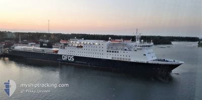
SIRENA SEAWAYS
Ro-Ro/Passenger Ship
Current Trip
| Time Travelled | 5 h, 2 mins |
|---|---|
| Remaining Time | 4 h, 43 mins |
| Distance Travelled | 78.11 nm |
| Remaining Distance | 77.12 nm |
| AVG Speed | 16.1 Knots |
| MAX Speed | 16.6 Knots |
| AVG Wind | 13.8 knots |
| MAX Wind | 19 knots |
| MIN Temp | -0.3°C / 31.46°F |
| MAX Temp | 1°C / 33.8°F |
| Dybgang | 5.5 m |
| Position Modtaget | 1 m siden |
Current Position
| Longitude | 21.49369° |
|---|---|
| Latitude | 59.56614° |
| Status | Under way using engine |
| Fart | 15.9 Knots |
| Kurs | 274.9° |
| Område | Baltic Sea |
| Station | T-AIS |
| Position Modtaget | 1 m siden |
Info
Information
The current position of SIRENA SEAWAYS is in Baltic Sea with coordinates 59.56614° / 21.49369° as reported on 2024-04-19 11:46 by AIS to our vessel tracker app. The vessel's current speed is 15.9 Knots and is heading at the port of KAPELLSKAR. The estimated time of arrival as calculated by MyShipTracking vessel tracking app is 2024-04-19 16:31 LT
The vessel SIRENA SEAWAYS (IMO: 9212163, MMSI: 277569000) is a Ro-Ro/Passenger Ship that was built in 2003 ( 21 år gamle ). It's sailing under the flag of [LT] Lithuania.
In this page you can find informations about the vessels current position, last detected port calls, and current voyage information. If the vessels is not in coverage by AIS you will find the latest position.
The current position of SIRENA SEAWAYS is detected by our AIS receivers and we are not responsible for the reliability of the data. The last position was recorded while the vessel was in Coverage by the Ais receivers of our vessel tracking app.
The current draught of SIRENA SEAWAYS as reported by AIS is 5.5 meters
Weather
| Temperature | -0.1°C / 31.82°F |
|---|---|
| Wind Speed | 10 knots |
| Direction | 43° NE |
| Pressure | 1008.2 hPa |
| Humidity | 62.6 % |
| Cloud Coverage | 42 % |
Featured Company
Last Port Calls
| Port | Arrival | Departure | Time In Port |
|---|---|---|---|
| 2024-04-19 04:39 | 2024-04-19 06:46 | 2 h | |
| 2024-04-18 16:46 | 2024-04-18 18:51 | 2 h | |
| 2024-04-18 04:39 | 2024-04-18 06:55 | 2 h | |
| 2024-04-17 05:21 | 2024-04-17 19:24 | 14 h | |
| 2024-04-16 16:39 | 2024-04-16 19:23 | 2 h | |
| 2024-04-16 05:16 | 2024-04-16 06:58 | 1 h | |
| 2024-04-15 16:41 | 2024-04-15 18:54 | 2 h | |
| 2024-04-15 05:15 | 2024-04-15 07:08 | 1 h | |
| 2024-04-14 16:40 | 2024-04-14 19:55 | 3 h | |
| 2024-04-14 05:16 | 2024-04-14 07:12 | 1 h |
Most Visited Ports (Last year)
| Port | Arrivals | |
|---|---|---|
| 296 | ||
| 265 |
Last Trips
| Origin | Departure | Destination | Arrival | Distance | |
|---|---|---|---|---|---|
| 2024-04-18 20:51 | 2024-04-19 07:39 | 156.90 nm | |||
| 2024-04-18 09:55 | 2024-04-18 18:46 | 156.27 nm | |||
| 2024-04-17 21:24 | 2024-04-18 07:39 | 156.86 nm | |||
| 2024-04-16 22:23 | 2024-04-17 07:21 | 156.73 nm | |||
| 2024-04-16 08:58 | 2024-04-16 19:39 | 153.74 nm | |||
| 2024-04-15 21:54 | 2024-04-16 07:16 | 156.12 nm | |||
| 2024-04-15 09:08 | 2024-04-15 19:41 | 156.32 nm | |||
| 2024-04-14 22:55 | 2024-04-15 07:15 | 156.94 nm | |||
| 2024-04-14 09:12 | 2024-04-14 19:40 | 156.25 nm | |||
| 2024-04-13 21:47 | 2024-04-14 07:16 | 154.77 nm |
Events
| Tid | Hændelsen | Detaljer | Position / Dest | Info |
|---|---|---|---|---|
| 2024-04-19 10:45 | Indenfor Dækning |
59.54880 / 22.02026
Baltic Sea
EE PLN <=> SE KPS
|
Fart: 15.9 kn Kurs: 274.2° |
|
| 2024-04-19 09:05 | Udenfor Dækning |
59.50669 / 22.89951
Baltic Sea
EE PLN <=> SE KPS
|
Fart: 16.5 kn Kurs: 283.5° |
|
| 2024-04-19 09:05 | Fundet i havområde | Finnish part of the Baltic Sea |
59.50669 / 22.89951
Baltic Sea
EE PLN <=> SE KPS
|
Fart: 16.5 kn Kurs: 283.5° |
| 2024-04-19 09:05 | Indenfor Dækning |
59.50669 / 22.89951
Baltic Sea
EE PLN <=> SE KPS
|
Fart: 16.5 kn Kurs: 283.5° |
|
| 2024-04-19 07:26 | Udenfor Dækning |
59.40453 / 23.73354
Gulf of Finland
EE PLN <=> SE KPS
|
Fart: 15.7 kn Kurs: 282.6° |
|
| 2024-04-19 06:46 | Afsejlet fra sidste havn |
|
59.34561 / 24.04240
EE PLN <=> SE KPS
|
Fart: 5.5 kn Kurs: 288° |
| 2024-04-19 06:44 | START Sejllads |
59.34665 / 24.04784
[EE] PALDISKI
|
Fart: 4.3 kn Kurs: 211° |
|
| 2024-04-19 06:29 | Dybgangen er ændret | 5.5 5.4 |
59.34834 / 24.05046
[EE] PALDISKI
|
Fart: Kurs: 151° |
| 2024-04-19 06:29 | Status er ændret | Under way using engine Moored |
59.34835 / 24.05047
[EE] PALDISKI
|
Fart: Kurs: 151° |
| 2024-04-19 05:02 | Dybgangen er ændret | 5.4 6 |
59.34834 / 24.05045
[EE] PALDISKI
|
Fart: Kurs: 151° |