
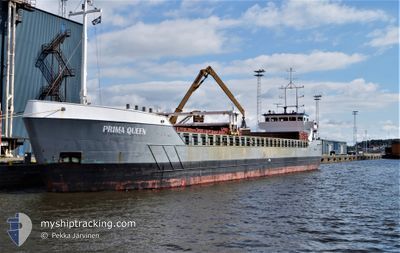
PRIMA QUEEN
General Cargo
Current Trip
| Time Travelled | 1 day |
|---|---|
| Remaining Time | 1 h, 51 mins |
| Distance Travelled | 284.71 nm |
| Remaining Distance | 19.53 nm |
| AVG Speed | 10.2 Knots |
| MAX Speed | 11.7 Knots |
| AVG Wind | 7.8 knots |
| MAX Wind | 18 knots |
| MIN Temp | -1°C / 30.2°F |
| MAX Temp | 2.6°C / 36.68°F |
| Dybgang | 5.8 m |
| Position Modtaget | Nu |
Current Position
| Longitude | 24.50156° |
|---|---|
| Latitude | 59.63798° |
| Status | Under way using engine |
| Fart | 9.6 Knots |
| Kurs | 96.3° |
| Område | Gulf of Finland |
| Station | T-AIS |
| Position Modtaget | Nu |
Info
Information
The current position of PRIMA QUEEN is in Gulf of Finland with coordinates 59.63798° / 24.50156° as reported on 2024-04-19 07:51 by AIS to our vessel tracker app. The vessel's current speed is 9.6 Knots and is heading at the port of MUUGA. The estimated time of arrival as calculated by MyShipTracking vessel tracking app is 2024-04-19 09:43 LT
The vessel PRIMA QUEEN (IMO: 9194282, MMSI: 230673000) is a General Cargo that was built in 2000 ( 24 år gamle ). It's sailing under the flag of [FI] Finland.
In this page you can find informations about the vessels current position, last detected port calls, and current voyage information. If the vessels is not in coverage by AIS you will find the latest position.
The current position of PRIMA QUEEN is detected by our AIS receivers and we are not responsible for the reliability of the data. The last position was recorded while the vessel was in Coverage by the Ais receivers of our vessel tracking app.
The current draught of PRIMA QUEEN as reported by AIS is 5.8 meters
Weather
| Temperature | -0.6°C / 30.92°F |
|---|---|
| Wind Speed | 18 knots |
| Direction | 51° NE |
| Pressure | 1008.8 hPa |
| Humidity | 73.1 % |
| Cloud Coverage | 100 % |
Featured Company
Last Port Calls
| Port | Arrival | Departure | Time In Port |
|---|---|---|---|
| 2024-04-16 08:42 | 2024-04-17 17:41 | 1 d | |
| 2024-04-11 09:35 | 2024-04-11 19:07 | 9 h | |
| 2024-04-09 17:57 | |||
| 2024-04-06 06:07 | 2024-04-07 16:38 | 1 d | |
| 2024-04-05 12:25 | 2024-04-05 21:54 | 9 h | |
| 2024-03-31 18:11 | 2024-04-03 20:04 | 3 d | |
| 2024-03-29 09:01 | 2024-03-30 00:30 | 15 h | |
| 2024-03-25 19:08 | 2024-03-27 16:37 | 1 d | |
| 2024-03-19 12:16 | 2024-03-21 18:59 | 2 d | |
| 2024-03-09 02:37 | 2024-03-13 15:40 | 4 d |
Last Trips
| Origin | Departure | Destination | Arrival | Distance | |
|---|---|---|---|---|---|
| 2024-04-11 22:07 | 2024-04-16 11:42 | 442.89 nm | |||
| 2024-04-09 20:57 | 2024-04-11 12:35 | 274.26 nm | |||
| 2024-04-06 00:54 | 2024-04-06 09:07 | 84.53 nm | |||
| 2024-04-03 23:04 | 2024-04-05 15:25 | 288.19 nm | |||
| 2024-03-30 01:30 | 2024-03-31 21:11 | 424.44 nm | |||
| 2024-03-27 18:37 | 2024-03-29 10:01 | 420.84 nm | |||
| 2024-03-21 19:59 | 2024-03-25 21:08 | 770.48 nm | |||
| 2024-03-13 16:40 | 2024-03-19 13:16 | 1025.62 nm | |||
| 2024-03-02 21:45 | 2024-03-09 03:37 | 775.53 nm | |||
| 2024-02-26 14:48 | 2024-03-02 06:59 | 620.22 nm |
Events
| Tid | Hændelsen | Detaljer | Position / Dest | Info |
|---|---|---|---|---|
| 2024-04-19 06:42 | Fundet i havområde | Estonian part of the Gulf of Finland |
59.65999 / 24.13033
Gulf of Finland
EEMUG
|
Fart: 10 kn Kurs: 95.7° |
| 2024-04-19 06:42 | Indenfor Dækning |
59.65999 / 24.13033
Gulf of Finland
EEMUG
|
Fart: 10 kn Kurs: 95.7° |
|
| 2024-04-19 04:09 | Udenfor Dækning |
59.69678 / 23.31748
Gulf of Finland
EEMUG
|
Fart: 9.7 kn Kurs: 97.6° |
|
| 2024-04-19 02:46 | Ændre havområde | Finnish part of the Gulf of Finland Finnish part of the Baltic Sea |
59.78216 / 22.92864
Gulf of Finland
EEMUG
|
Fart: 10 kn Kurs: 95.5° |
| 2024-04-19 02:34 | Ændre havområde | Finnish part of the Baltic Sea Finnish part of the Gulf of Bothnia |
59.79628 / 22.87173
Baltic Sea
EEMUG
|
Fart: 10.2 kn Kurs: 142.2° |
| 2024-04-18 21:42 | ETA er ændret | 2024/04/19 10:00 2024/04/19 09:00 |
60.22456 / 22.06203
EEMUG
|
Fart: 10.1 kn Kurs: 80.9° |
| 2024-04-18 19:41 | Indenfor Dækning |
60.39260 / 21.55514
Gulf of Bothnia
EEMUG
|
Fart: 10.1 kn Kurs: 124.3° |
|
| 2024-04-18 14:52 | Udenfor Dækning |
61.01034 / 20.97176
Gulf of Bothnia
EEMUG
|
Fart: 10.1 kn Kurs: 190.6° |
|
| 2024-04-18 12:11 | START Sejllads | 1.76 nm, North East of OLKILUOTO |
61.25097 / 21.48728
EEMUG
|
Fart: 3.6 kn Kurs: 282° |
| 2024-04-18 11:58 | Status er ændret | Under way using engine Moored |
61.24872 / 21.48904
EEMUG
|
Fart: Kurs: 170° |