
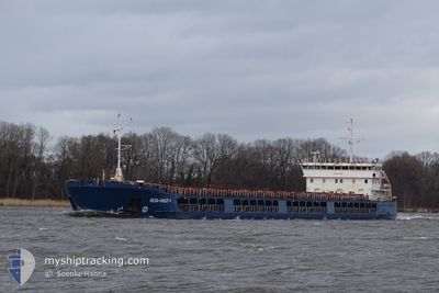
NEVA-LEADER 4
General Cargo
Current Trip
| Time Travelled | 1 day |
|---|---|
| Remaining Time | --- |
| Distance Travelled | 106.54 nm |
| Remaining Distance | --- |
| AVG Speed | 7.7 Knots |
| MAX Speed | 10.5 Knots |
| AVG Wind | 7.5 knots |
| MAX Wind | 16 knots |
| MIN Temp | 11.3°C / 52.34°F |
| MAX Temp | 15.9°C / 60.62°F |
| Dybgang | 3.2 m |
| Position Modtaget | Nu |
Current Position
| Longitude | 29.14935° |
|---|---|
| Latitude | 41.23006° |
| Status | Under way using engine |
| Fart | 9.4 Knots |
| Kurs | 44.7° |
| Område | Sea of Marmara |
| Station | T-AIS |
| Position Modtaget | Nu |
Info
Information
The current position of NEVA-LEADER 4 is in Sea of Marmara with coordinates 41.23006° / 29.14935° as reported on 2024-04-19 02:37 by AIS to our vessel tracker app. The vessel's current speed is 9.4 Knots and is heading at the port of ROSTOV-ON-DON. The estimated time of arrival as calculated by MyShipTracking vessel tracking app is 2024-04-23 06:00 LT
The vessel NEVA-LEADER 4 (IMO: 9598842, MMSI: 273359980) is a General Cargo that was built in 2013 ( 11 år gamle ). It's sailing under the flag of [RU] Russia.
In this page you can find informations about the vessels current position, last detected port calls, and current voyage information. If the vessels is not in coverage by AIS you will find the latest position.
The current position of NEVA-LEADER 4 is detected by our AIS receivers and we are not responsible for the reliability of the data. The last position was recorded while the vessel was in Coverage by the Ais receivers of our vessel tracking app.
The current draught of NEVA-LEADER 4 as reported by AIS is 3.2 meters
Weather
| Temperature | 11.9°C / 53.42°F |
|---|---|
| Wind Speed | 6 knots |
| Direction | 8° N |
| Pressure | 1011.4 hPa |
| Humidity | 85.5 % |
| Cloud Coverage | 100 % |
Featured Company
Events
| Tid | Hændelsen | Detaljer | Position / Dest | Info |
|---|---|---|---|---|
| 2024-04-19 01:25 | ETA er ændret | 2024/04/23 06:00 2024/04/22 05:00 |
41.08548 / 29.06345
RU ROV
|
Fart: 7.7 kn Kurs: 0.7° |
| 2024-04-19 01:17 | Destination er ændret | RU ROV RU AZO |
41.07292 / 29.05183
RU ROV
|
Fart: 7.2 kn Kurs: 23° |
| 2024-04-18 22:16 | START Sejllads | 13.37 nm, South of YESILKOY |
40.73291 / 28.84583
RU AZO
|
Fart: 3.2 kn Kurs: 74° |
| 2024-04-18 15:17 | STOP Sejllads | 9.46 nm, South West of MALTEPE |
40.81525 / 28.96754
RU AZO
|
Fart: 0.3 kn Kurs: 69° |
| 2024-04-18 13:45 | START Sejllads | 12.36 nm, South of YESILKOY |
40.75175 / 28.78426
RU AZO
|
Fart: 3.8 kn Kurs: 29° |
| 2024-04-18 07:18 | STOP Sejllads | 9.59 nm, South of YESILKOY |
40.79750 / 28.85904
RU AZO
|
Fart: 0.3 kn Kurs: 163° |
| 2024-04-18 03:43 | Status er ændret | Under way using engine Default |
40.66109 / 28.50621
RU AZO
|
Fart: 9.9 kn Kurs: 57° |
| 2024-04-18 03:21 | Status er ændret | Default Under way using engine |
40.62401 / 28.44008
RU AZO
|
Fart: 10.3 kn Kurs: 53.5° |
| 2024-04-18 03:13 | Status er ændret | Under way using engine Default |
40.61003 / 28.41550
RU AZO
|
Fart: 10.5 kn Kurs: 53° |
| 2024-04-18 02:31 | Status er ændret | Default Under way using engine |
40.54026 / 28.28989
RU AZO
|
Fart: 10.1 kn Kurs: 45.9° |