
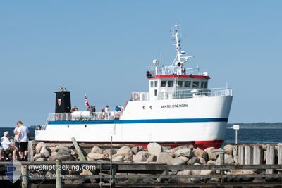
NEKSELOEFAERGEN
Passenger
Current Trip
HAVNSOE>NEKSELOE
| Time Travelled | --- |
|---|---|
| Remaining Time | --- |
| Distance Travelled | 950.37 nm |
| Remaining Distance | --- |
| AVG Speed | 7.7 Knots |
| MAX Speed | 11.4 Knots |
| AVG Wind | 13.8 knots |
| MAX Wind | 28.8 knots |
| MIN Temp | -5.8°C / 21.56°F |
| MAX Temp | 7.7°C / 45.86°F |
| Dybgang | 2 m |
| Position Modtaget | 2 m siden |
Current Position
| Longitude | 11.32563° |
|---|---|
| Latitude | 55.75409° |
| Status | Moored |
| Fart | |
| Kurs | 30° |
| Område | Kattegat |
| Station | T-AIS |
| Position Modtaget | 2 m siden |
Info
Information
The current position of NEKSELOEFAERGEN is in Kattegat with coordinates 55.75409° / 11.32563° as reported on 2024-04-24 18:48 by AIS to our vessel tracker app. The vessel's current speed is 0 Knots
The vessel NEKSELOEFAERGEN (IMO: 9074377, MMSI: 219000899) is a Passenger It's sailing under the flag of [DK] Denmark.
In this page you can find informations about the vessels current position, last detected port calls, and current voyage information. If the vessels is not in coverage by AIS you will find the latest position.
The current position of NEKSELOEFAERGEN is detected by our AIS receivers and we are not responsible for the reliability of the data. The last position was recorded while the vessel was in Coverage by the Ais receivers of our vessel tracking app.
The current draught of NEKSELOEFAERGEN as reported by AIS is 2 meters
Weather
| Temperature | 6.1°C / 42.98°F |
|---|---|
| Wind Speed | 10 knots |
| Direction | 118° ESE |
| Pressure | 1006.3 hPa |
| Humidity | 69.3 % |
| Cloud Coverage | 86 % |
Featured Company
Last Port Calls
Most Visited Ports (Last year)
| Port | Arrivals | |
|---|---|---|
| 2 |
Last Trips
| Origin | Departure | Destination | Arrival | Distance |
|---|
Events
| Tid | Hændelsen | Detaljer | Position / Dest | Info |
|---|---|---|---|---|
| 2024-04-24 14:27 | Status er ændret | Moored Under way using engine |
55.75409 / 11.32562
HAVNSOE>NEKSELOE
|
Fart: 0.1 kn Kurs: 33° |
| 2024-04-24 14:23 | STOP Sejllads | 9.49 nm, North East of KALUNDBORG |
55.75411 / 11.32564
HAVNSOE>NEKSELOE
|
Fart: 0.3 kn Kurs: 30° |
| 2024-04-24 14:04 | START Sejllads | 9.84 nm, North East of KALUNDBORG |
55.78174 / 11.30138
HAVNSOE>NEKSELOE
|
Fart: 7.1 kn Kurs: 78° |
| 2024-04-24 13:48 | STOP Sejllads | 9.75 nm, North East of KALUNDBORG |
55.78156 / 11.29781
HAVNSOE>NEKSELOE
|
Fart: 0.2 kn Kurs: 138° |
| 2024-04-24 13:30 | START Sejllads | 9.55 nm, North East of KALUNDBORG |
55.75609 / 11.32569
HAVNSOE>NEKSELOE
|
Fart: 6.7 kn Kurs: 339.5° |
| 2024-04-24 13:11 | Status er ændret | Under way using engine Moored |
55.75410 / 11.32562
HAVNSOE>NEKSELOE
|
Fart: Kurs: 30° |
| 2024-04-24 05:47 | Destination er ændret | HAVNSOE>NEKSELOE HAVNSOE>SEJEROE |
55.75410 / 11.32563
HAVNSOE>NEKSELOE
|
Fart: Kurs: 33° |
| 2024-04-24 01:05 | Status er ændret | Moored Default |
55.75410 / 11.32563
HAVNSOE>SEJEROE
|
Fart: Kurs: 34° |
| 2024-04-24 01:02 | Status er ændret | Default Moored |
55.75409 / 11.32563
HAVNSOE>SEJEROE
|
Fart: Kurs: 35° |
| 2024-04-23 17:52 | Status er ændret | Moored Under way using engine |
55.75410 / 11.32564
HAVNSOE>SEJEROE
|
Fart: 0.1 kn Kurs: 34° |