
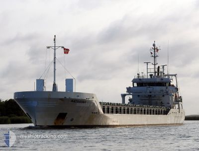
KATARIINA
General Cargo
Current Trip
| Time Travelled | 3 days |
|---|---|
| Remaining Time | --- |
| Distance Travelled | 463.71 nm |
| Remaining Distance | --- |
| AVG Speed | 8.4 Knots |
| MAX Speed | 13.4 Knots |
| AVG Wind | 11.4 knots |
| MAX Wind | 24.9 knots |
| MIN Temp | 1.7°C / 35.06°F |
| MAX Temp | 8.7°C / 47.66°F |
| Dybgang | 5.5 m |
| Position Modtaget | 2 d siden |
Current Position
| Longitude | 1.30084° |
|---|---|
| Latitude | 53.60989° |
| Status | Under way using engine |
| Fart | 9.5 Knots |
| Kurs | 252.4° |
| Område | North Sea |
| Station | T-AIS |
| Position Modtaget | 2 d siden |
Info
Information
The current position of KATARIINA is in North Sea with coordinates 53.60989° / 1.30084° as reported on 2024-04-22 03:14 by AIS to our vessel tracker app. The vessel's current speed is 9.5 Knots
The vessel KATARIINA (IMO: 9467213, MMSI: 305211000) is a General Cargo that was built in 2011 ( 13 år gamle ). It's sailing under the flag of [AG] Antigua Barbuda.
In this page you can find informations about the vessels current position, last detected port calls, and current voyage information. If the vessels is not in coverage by AIS you will find the latest position.
The current position of KATARIINA is detected by our AIS receivers and we are not responsible for the reliability of the data. The last position was recorded while the vessel was in Coverage by the Ais receivers of our vessel tracking app.
The current draught of KATARIINA as reported by AIS is 5.5 meters
Weather
| Temperature | 6.3°C / 43.34°F |
|---|---|
| Wind Speed | 25 knots |
| Direction | 347° NNW |
| Pressure | 1017.3 hPa |
| Humidity | 68.1 % |
| Cloud Coverage | 100 % |
Featured Company
Last Port Calls
| Port | Arrival | Departure | Time In Port |
|---|---|---|---|
| 2024-04-17 17:26 | 2024-04-20 04:39 | 2 d | |
| 2024-04-16 03:00 | 2024-04-16 14:28 | 11 h | |
| 2024-04-12 10:15 | 2024-04-14 06:26 | 1 d | |
| 2024-04-08 15:58 | 2024-04-10 08:28 | 1 d | |
| 2024-04-04 16:08 | 2024-04-05 15:29 | 23 h | |
| 2024-03-31 07:15 | 2024-04-03 17:07 | 3 d | |
| 2024-03-26 22:27 | 2024-03-27 17:05 | 18 h | |
| 2024-03-23 21:56 | 2024-03-26 16:43 | 2 d | |
| 2024-03-19 08:34 | 2024-03-20 20:00 | 1 d | |
| 2024-03-14 16:54 | 2024-03-16 03:46 | 1 d |
Last Trips
| Origin | Departure | Destination | Arrival | Distance | |
|---|---|---|---|---|---|
| 2024-04-16 16:28 | 2024-04-17 19:26 | 154.15 nm | |||
| 2024-04-14 09:26 | 2024-04-16 05:00 | 435.46 nm | |||
| 2024-04-10 10:28 | 2024-04-12 13:15 | 568.84 nm | |||
| 2024-04-05 17:29 | 2024-04-08 17:58 | 343.17 nm | |||
| 2024-04-03 19:07 | 2024-04-04 18:08 | 217.92 nm | |||
| 2024-03-27 18:05 | 2024-03-31 09:15 | 220.59 nm | |||
| 2024-03-26 17:43 | 2024-03-26 23:27 | 54.48 nm | |||
| 2024-03-20 23:00 | 2024-03-23 22:56 | 763.24 nm | |||
| 2024-03-16 04:46 | 2024-03-19 11:34 | 710.86 nm | |||
| 2024-03-11 04:12 | 2024-03-14 17:54 | 710.25 nm |
Events
| Tid | Hændelsen | Detaljer | Position / Dest | Info |
|---|---|---|---|---|
| 2024-04-22 07:44 | STOP Sejllads | 18.5 nm, East of GRIMSBY |
53.59667 / .44833
GBNHO
|
Fart: Kurs: -1° |
| 2024-04-22 03:26 | Status er ændret | Default Under way using engine |
53.60166 / 1.25167
GBNHO
|
Fart: 9.5 kn Kurs: 252.4° |
| 2024-04-22 03:14 | Udenfor Dækning |
53.60989 / 1.30084
North Sea
GBNHO
|
Fart: 9.5 kn Kurs: 252.4° |
|
| 2024-04-22 01:38 | Fundet i havområde | United Kingdom part of the North Sea |
53.66077 / 1.72896
North Sea
GBNHO
|
Fart: 9.8 kn Kurs: 262.6° |
| 2024-04-22 01:35 | Status er ændret | Under way using engine Default |
53.66173 / 1.74110
GBNHO
|
Fart: 9 kn Kurs: 262° |
| 2024-04-22 01:26 | Indenfor Dækning |
53.66077 / 1.72896
North Sea
GBNHO
|
Fart: 9.8 kn Kurs: 262.6° |
|
| 2024-04-21 09:53 | Status er ændret | Default Under way using engine |
54.15500 / 5.98333
GBNHO
|
Fart: 9.1 kn Kurs: 262.1° |
| 2024-04-21 09:49 | Udenfor Dækning |
54.15614 / 5.99881
North Sea
GBNHO
|
Fart: 9.1 kn Kurs: 262.1° |
|
| 2024-04-21 09:46 | Ændre havområde | Dutch part of the North Sea German part of the North Sea |
54.15725 / 6.01260
North Sea
GBNHO
|
Fart: 9.2 kn Kurs: 262.5° |
| 2024-04-21 09:44 | Status er ændret | Under way using engine Default |
54.15803 / 6.02285
GBNHO
|
Fart: 9.1 kn Kurs: 262° |