
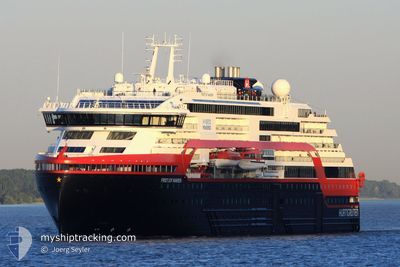
FRIDTJOF NANSEN
Passenger
Current Trip
DAMOY
| Time Travelled | 9 days |
|---|---|
| Remaining Time | --- |
| Distance Travelled | 1628.67 nm |
| Remaining Distance | --- |
| AVG Speed | 9.5 Knots |
| MAX Speed | 16 Knots |
| AVG Wind | 9.9 knots |
| MAX Wind | 26.8 knots |
| MIN Temp | -5.5°C / 22.1°F |
| MAX Temp | 11.2°C / 52.16°F |
| Dybgang | 5.5 m |
| Position Modtaget | 2 m siden |
Current Position
| Longitude | --- |
|---|---|
| Latitude | --- |
| Status | Under way using engine |
| Fart | 8.2 Knots |
| Kurs | 352° |
| Område | South Atlantic Ocean |
| Station | T-AIS |
| Position Modtaget | 2 m siden |
Info
Information
The current position of FRIDTJOF NANSEN is in South Atlantic Ocean with coordinates -55.51122° / -66.25009° as reported on 2025-12-09 22:46 by AIS to our vessel tracker app. The vessel's current speed is 8.2 Knots
The vessel FRIDTJOF NANSEN (IMO: 9813084, MMSI: 257088070) is a Passenger It's sailing under the flag of [NO] Norway.
In this page you can find informations about the vessels current position, last detected port calls, and current voyage information. If the vessels is not in coverage by AIS you will find the latest position.
The current position of FRIDTJOF NANSEN is detected by our AIS receivers and we are not responsible for the reliability of the data. The last position was recorded while the vessel was in Coverage by the Ais receivers of our vessel tracking app.
The current draught of FRIDTJOF NANSEN as reported by AIS is 5.5 meters
Weather
| Temperature | 7.1°C / 44.78°F |
|---|---|
| Wind Speed | 17 knots |
| Direction | 245° WSW |
| Pressure | 994.8 hPa |
| Humidity | 72.8 % |
| Cloud Coverage | 100 % |
Featured Company
Last Port Calls
| Port | Arrival | Departure | Time In Port |
|---|---|---|---|
| 2025-11-30 05:59 | 2025-11-30 18:28 | 12 h | |
| 2025-11-19 12:45 | 2025-11-20 19:03 | 1 d | |
| 2025-11-09 19:43 | 2025-11-10 21:07 | 1 d | |
| 2025-10-30 19:49 | 2025-10-31 19:23 | 23 h | |
| 2025-10-30 08:45 | 2025-10-30 17:33 | 8 h | |
| 2025-10-17 12:03 | 2025-10-17 21:25 | 9 h | |
| 2025-10-01 19:03 | 2025-10-02 08:10 | 13 h |
Last Trips
| Origin | Departure | Destination | Arrival | Distance | |
|---|---|---|---|---|---|
| 2025-11-20 19:03 | 2025-11-30 05:59 | 1587.00 nm | |||
| 2025-11-10 21:07 | 2025-11-19 12:45 | 1663.62 nm | |||
| 2025-10-31 19:23 | 2025-11-09 19:43 | 1600.44 nm | |||
| 2025-10-30 17:33 | 2025-10-30 19:49 | 27.19 nm | |||
| 2025-10-17 21:25 | 2025-10-30 08:45 | 2479.51 nm | |||
| 2025-10-02 08:10 | 2025-10-17 12:03 | 5117.49 nm | |||
| 2025-09-28 09:23 | 2025-10-01 19:03 | 1135.60 nm |
Events
| Tid | Hændelsen | Detaljer | Position / Dest | Info |
|---|---|---|---|---|
| 2025-12-09 22:11 | Status er ændret | Under way using engine Default |
-55.59170 / -66.22429
DAMOY
|
Fart: 8.4 kn Kurs: 350° |
| 2025-12-09 22:09 | Status er ændret | Default Under way using engine |
-55.59671 / -66.22262
DAMOY
|
Fart: 8.1 kn Kurs: 357.5° |
| 2025-12-09 21:50 | Status er ændret | Under way using engine Default |
-55.64055 / -66.21356
DAMOY
|
Fart: 8.4 kn Kurs: 353° |
| 2025-12-09 21:23 | Status er ændret | Default Under way using engine |
-55.70334 / -66.19500
DAMOY
|
Fart: 7.6 kn Kurs: 354.4° |
| 2025-12-09 21:15 | Ændre havområde | Chilean (disputed - Chilean point of view) part of the South Atlantic Ocean Antarctic 200NM zone beyond the coastline part of the Southern Ocean |
-55.71925 / -66.19052
South Atlantic Ocean
|
Fart: 7.8 kn Kurs: 344.6° |
| 2025-12-09 21:15 | Status er ændret | Under way using engine Default |
-55.71925 / -66.19052
DAMOY
|
Fart: 8 kn Kurs: 351° |
| 2025-12-09 21:05 | Indenfor Dækning |
-55.71925 / -66.19052
South Atlantic Ocean
|
Fart: 7.8 kn Kurs: 344.6° |
|
| 2025-12-07 23:06 | START Sejllads |
-64.80081 / -63.49658
DAMOY
|
Fart: 9.2 kn Kurs: 32° |
|
| 2025-12-07 16:21 | STOP Sejllads |
-64.80957 / -63.49875
DAMOY
|
Fart: Kurs: 180° |
|
| 2025-12-07 15:53 | START Sejllads |
-64.81140 / -63.53066
DAMOY
|
Fart: 6.5 kn Kurs: 37° |