
BLUES
General Cargo
Current Trip
ROCND
| Time Travelled | 8 days |
|---|---|
| Remaining Time | --- |
| Distance Travelled | 435.58 nm |
| Remaining Distance | --- |
| AVG Speed | 9.5 Knots |
| MAX Speed | 17 Knots |
| AVG Wind | 7 knots |
| MAX Wind | 23.8 knots |
| MIN Temp | 9.6°C / 49.28°F |
| MAX Temp | 29°C / 84.2°F |
| Dybgang | 4.8 m |
| Position Modtaget | 5 d siden |
Current Position
| Longitude | 28.68452° |
|---|---|
| Latitude | 44.10411° |
| Status | Under way using engine |
| Fart | 5.3 Knots |
| Kurs | 81.7° |
| Område | Black Sea |
| Station | T-AIS |
| Position Modtaget | 5 d siden |
Info
Information
The current position of BLUES is in Black Sea with coordinates 44.10411° / 28.68452° as reported on 2024-04-18 09:59 by AIS to our vessel tracker app. The vessel's current speed is 5.3 Knots
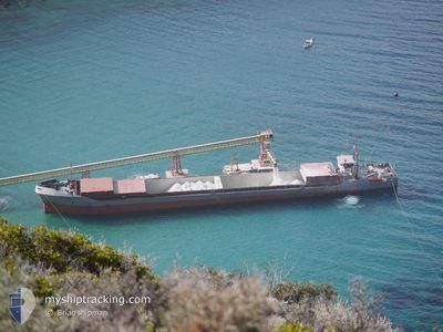
The vessel BLUES (IMO: 8901030, MMSI: 518915000) is a General Cargo that was built in 1990 ( 34 år gamle ). It's sailing under the flag of [CK] Cook Is.
In this page you can find informations about the vessels current position, last detected port calls, and current voyage information. If the vessels is not in coverage by AIS you will find the latest position.
The current position of BLUES is detected by our AIS receivers and we are not responsible for the reliability of the data. The last position was recorded while the vessel was in Coverage by the Ais receivers of our vessel tracking app.
The current draught of BLUES as reported by AIS is 4.8 meters
Weather
| Temperature | 14°C / 57.2°F |
|---|---|
| Wind Speed | 6 knots |
| Direction | 82° E |
| Pressure | 1020.5 hPa |
| Humidity | 70.6 % |
| Cloud Coverage | 83 % |
Featured Company
Last Port Calls
| Port | Arrival | Departure | Time In Port |
|---|---|---|---|
| 2024-04-15 08:50 | 2024-04-15 09:46 | 56 m | |
| 2024-04-14 08:19 | 2024-04-14 10:25 | 2 h | |
| 2024-04-11 09:50 | 2024-04-11 12:38 | 2 h | |
| 2024-04-06 06:22 | 2024-04-09 11:23 | 3 d | |
| 2024-04-03 07:17 | 2024-04-04 16:49 | 1 d | |
| 2024-03-31 03:26 | 2024-03-31 04:45 | 1 h | |
| 2024-03-15 09:38 | 2024-03-15 11:51 | 2 h | |
| 2024-03-12 14:18 | 2024-03-12 15:05 | 47 m | |
| 2024-03-08 05:29 | 2024-03-08 13:03 | 7 h | |
| 2024-03-06 18:22 |
Last Trips
| Origin | Departure | Destination | Arrival | Distance | |
|---|---|---|---|---|---|
| 2024-04-14 13:25 | 2024-04-15 11:50 | 185.57 nm | |||
| 2024-04-11 15:38 | 2024-04-14 11:19 | 489.66 nm | |||
| 2024-04-09 14:23 | 2024-04-11 12:50 | 263.79 nm | |||
| 2024-04-04 19:49 | 2024-04-06 09:22 | 190.49 nm | |||
| 2024-03-31 07:45 | 2024-04-03 10:17 | 247.39 nm | |||
| 2024-03-15 13:51 | 2024-03-31 06:26 | 884.55 nm | |||
| 2024-03-12 17:05 | 2024-03-15 11:38 | 20.30 nm | |||
| 2024-03-08 15:03 | 2024-03-12 16:18 | 668.79 nm | |||
| 2024-03-06 20:22 | 2024-03-08 07:29 | 292.06 nm | |||
| 2024-02-17 06:39 | 2024-02-17 15:08 | 80.01 nm |
Events
| Tid | Hændelsen | Detaljer | Position / Dest | Info |
|---|---|---|---|---|
| 2024-04-23 16:37 | START Sejllads | 6.12 nm, West of TAMAN |
45.11494 / 36.51843
ROCND
|
Fart: 9.2 kn Kurs: 206° |
| 2024-04-23 13:56 | STOP Sejllads | 6.05 nm, West of TAMAN |
45.12423 / 36.51970
ROCND
|
Fart: Kurs: 198° |
| 2024-04-23 13:26 | START Sejllads | 6.08 nm, West of TAMAN |
45.12192 / 36.51891
ROCND
|
Fart: 14.4 kn Kurs: 190° |
| 2024-04-23 12:37 | STOP Sejllads | 6.03 nm, West of TAMAN |
45.12408 / 36.52002
ROCND
|
Fart: 0.2 kn Kurs: 217° |
| 2024-04-23 10:57 | START Sejllads | 11.95 nm, South of TAMAN |
44.93618 / 36.56577
ROCND
|
Fart: 10.4 kn Kurs: 281° |
| 2024-04-22 13:43 | STOP Sejllads | 11.46 nm, South of TAMAN |
44.93308 / 36.63820
ROCND
|
Fart: 0.3 kn Kurs: 193° |
| 2024-04-22 11:21 | START Sejllads | 11.39 nm, South of TAMAN |
44.93441 / 36.63576
ROCND
|
Fart: 17 kn Kurs: 302° |
| 2024-04-18 10:52 | Status er ændret | Default Under way using engine |
44.06161 / 28.85328
ROCND
|
Fart: 5.3 kn Kurs: 81.7° |
| 2024-04-18 09:59 | Udenfor Dækning |
44.10411 / 28.68452
Black Sea
|
Fart: 5.3 kn Kurs: 81.7° |
|
| 2024-04-18 09:47 | Fundet i havområde | Romanian part of the Black Sea |
44.10953 / 28.65342
Black Sea
|
Fart: 6.1 kn Kurs: 84.7° |